 Seventh Street between the B-line trail (at Morton Street) and Woodlawn Avenue
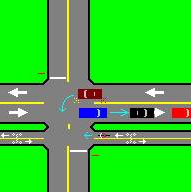
The city stupidly built a two-way bikeway along the south edge of Seventh Street.
This causes hidden conflicts where two drivers cannot see the other until it is too late.
This looks like it was designed by an idiot cyclist with the goal that the bicycle never has to stop.
Here are the reasons why these practices are dangerous:
- Approaching bicycles are invisible to vehicles waiting for left turns to clear (arrows).
- Too many conflicts are grouped together into a very tight space,
- Extra legs to intersections multiply conflicts and confusion.
- Trees planted between sidewalks, sidepaths, and streets hide vehicles and pedestrians from each other.
- None of these wrong ways of adding bicycle lanes or paths conforms to the normal laws governing lane use and right-of-way.
- None of these wrong ways of adding bicycle lanes or paths conforms to the MUCTD (Manual of Uniform Traffic Control Devices).
- A bicycle riding on the left side of a street is not coming from an expected direction, and may not be seen by drivers.
- Bicycles, unlike pedestrians, move too fast to be scanned for like drivers scan for pedestrians.
- Approaching bicycles are in the blind zones of drivers coming from the same direction.
Notice that all of the wrong ways of building bicycle lanes and sidepaths create unexpected conflicts, bring vehicles in from unexpected directions, or hide various traffic movements from each other. These dangers must be avoided.
Bloomfield Road (Indiana 45) at Curry Pike and Leonard Springs Road
One westbound lane is wasted, while the other lane is overloaded. The right lane is restricted to a right turn that is rarely used, while the left lane carries not only the traffic going straight on the highway, but also a heavily used left turn. The right lane should be extended beyond the intersection to the next intersection. This is causing many rear-end crashes on the exit ramps from Indiana 37. Drivers wanting the left lane stop on the ramps, waiting for the traffic light to create a gap. The driver behind, wanting the right lane, looks left to merge, and hits the stopped car from behind.
Third Street (Indiana 46) at Smith Road
This signal has the highest probability of causing the dangerous condition known as yellow trap. This causes accidents, and police often wrongly blame drivers for it. Flashing Yellow Arrows should be used to fix the trouble.
Tenth Street (Indiana 45) at Russell Road (west intersection)
This intersection has no left turn lane, and cars waiting to turn left onto Russell Road are being passed on the right by motorists illegally driving onto a shoulder that is not designed to be used as a passing lane. Occasionally, some vehicles that run out of room collide with a culvert the shoulder disappears under.
Walnut Street at Grimes Lane
This intersection is overloaded during the daytime. At night, it is on flashing, even though it has a sight distance problem, and the other intersections near it do not flash. It sorely needs a free right turn ramp from eastbound Grimes to southbound Walnut. If that can't be made, the existing lanes should be reconfigured for an exclusive right turn lane, and a combined straight and left lane. In this case, the signal should be redesigned to use split phasing on Grimes, and to add a right turn arrow concurrent with the left turn arrow for northbound Walnut.
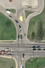
Here is another solution to this intersection using flashing yellow arrows
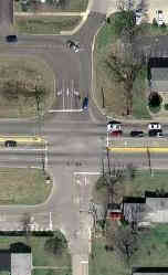 Third Street at Franklin Road, Fairfield Drive, Wynndale Drive, and a frontage road
This intersection (see image) is wrongly designed, wrongly built, and wrongly signed. The frontage road (lower left) should have been connected to Wynndale somewhere else. It is too close to Third Street, The overhead signs do not show the actual vehicle paths. And drivers on the frontage road somehow rationalize their way into thinking that a left turn followed by a right turn is an allowable movement on red.
Likewise, the intersection of Franklin and Fairfield (upper right) is also too close to Third Street. These two intersections were created from roads that used to be separated before the interchange between Third Street (Indiana 48) and Indiana 37 was built. But the major traffic generators on Franklin and the frontage road did not yet exist at that time.
This traffic signal is a major traffic jam location on Third Street, especially during rush hour, because the frontage road adds an extra green interval to the signal cycle. This means that there is less overall time available for Third Street. Adding to that delay is the fact that both Wynndale and the frontage road get dual clearance timing because the traffic passes through two sets of signals.
Another problem that backs up traffic is that the pedestrian pushbutton to cross Third Street is tied to Wynndale. Wynndale usually has very little vehicle traffic, and has a signal phase that can not occur at the same time as any other phase.
 The left turns on Third Street have been replaced with flashing yellow arrows, but the other problems still
remain.
The left turns on Third Street have been replaced with flashing yellow arrows, but the other problems still
remain.
They have replaced the signals at Wynndale and the frontage road with stop signs on northbound Wynndale and eastbound on the frontage road. This removes the right turn on red problem.
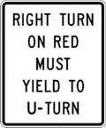
They put RIGHT TURN ON RED YIELD TO U-TURN signs on Franklin and Wynndale. Not only is this sign NOT in the
MUTCD, but the instruction is impossible to obey. You can't tell a left turn from a U-turn until it is too late.
Note: The sign has been added to the MUTCD, but telling which the driver is going to do is still very
hard.
Indiana 46 at Third Street and College Mall Road
Southbound 46 is backing up into College Mall Road because the next signal to the south (Eastland Plaza at College Mall Road) does not give enough green time to let all southbound traffic to pass. But part of the problem is that northbound traffic backs up from the Third Street light, blocking southbound left turns. Remedies:
- Lock the two signals in progression on College Mall Road. Don't let jurisdiction difference prevent this.
- Use phasings that make the progression work most effectively.
- Add lanes to remove some of the load from these signals.
- Remove the weaving problems on southbound Indiana 46 north of these signals. Two continuous lanes are needed for the Indian 46 left turn, and two lanes are needed for southbound to College Mall Road.
Whitehall Pike (Indiana 48) at Daniels Way
Why does a driveway to a house as the fourth leg of the intersection have its own phase? And why are the Daniels leg and the driveway operated with split phasing? Is it because a cop lives in that house? Two better solutions present themselves:
- Give Daniels a leading turn arrow. If the driveway has a call on it, terminate the turn arrow phase when its traffic ends, and show circular greens in both directions.
- Make the driveway and Daniels Way have concurrent circular greens, and put up a "LEFT TURN YIELD ON GREEN (ball)" sign.
Henderson Street at Allen Street
The stop signs on Henderson do not conform to the MUTCD. Politics should never be allowed in traffic control decisions. The councilmen who passed this ordinance should be thrown out of office, and never allowed to hold office again. Traffic control should not be in the hands of layman politicians or citizens' pressure groups. Trained engineers should have control of traffic.
Tenth Street at Walnut Street
This intersection also has a left turn signal without a left turn lane, also causing backups and driver confusion. The intersection and its signal should be redesigned to have dedicated left turn lanes.
Tapp Road
The speed limit is set at 30 mph, not because of any safety problem, but because a stupid state statute automatically sets all speed limits inside city limits to 30 mph. An expensive traffic study is required to change speed limits inside a city limit to any speed other than 30 mph. But the area is not built up. The road was annexed to make a medical facility farther down the road a "contiguous property," so the city could legally annex the medical facility. The same traffic conditions exist that existed before the annexation, when the speed limit was 40 mph. This political speed limit is causing drivers to speed, as they go the original design speed of the road. These solutions to this problem come to mind:
- Get rid of the stupid law.
- Require ALL speed limits to have the same traffic study.
- Require the design speed of the road to be used as the speed limit.
- Get rid of municipal governments. They are an unnecessary waste of tax money.
- Make it illegal to spend tax money on the arts. Then the city could afford the study.
- Take traffic control away from layman legislators, and give it to trained engineers, where it belongs.
Third Street between Mitchell Street and High Street
This is a five-block two-lane bottleneck in the middle of a four-lane road. Plans have been repeatedly made to make it four-lane, either by widening it, or by using Atwater Avenue to extend the one-way pair in use west of Mitchell. Each time, objections came from a neighborhood association and Indiana University. IU owns the land north of Third Street, and will not give any to widen the street (state universities are not subject to local eminent domain). The neighborhood association is against the use of Atwater Avenue, and is against tearing down any of the houses in the neighborhood. Other plans are impossible, because eminent domain can not be used against property belonging to churches. There are 2 churches and a mosque adjoining the various proposed routes.
Tenth Street at Jordan Avenue
This intersection badly needs overhead signs to explain the confusing array of lanes. But the overhead signs are not allowed, because IU does not want the "view of the architecture of the library" to be marred by overhead signs. How vain can you get?
The BLM movement forced the city rename Jordan Avenue as Eagleson Avenue because the scientist Jordan believed in Eugenics.
Third Street downtown
This section badly needs progression, but the city has a simultaneous system set up instead. The progression needs lagging left turns at some intersections, which the city will not do. No lagging left turns are allowed under the current city administration.
Walnut Street downtown
There is no through traffic lane continuity on northbound Walnut Street, even though the parallel southbound College Avenue has lane continuity. All of the original two lanes at Winslow Road end in right turns or lane drops. Traffic intending to go through Bloomington on Walnut must change lanes at least once.
This problem existed in the past, and was fixed in the 1990s. But the current administration brought it back. Rather than move lanes over gradually (because the surveys did not line up when the properties were platted), they went back to the stupidity of adding lanes on the left and dropping them on the right.
The planned location of the new Bloomington Hospital on the Indiana 45/46 Bypass
This is a bad location. Access to the hospital will be hampered by IU game traffic. And it will require yet another traffic signal on this highway that has too many signals already.
 Whitehall Pike, Liberty Drive, Runkle Way and the Marsh Supermarket
 The Northbound Indiana 37 entrance ramp from Second Street (Indiana 45)
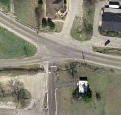 17th Street and Arlington Road at Monroe Street