| DURING FINAL CONSTRUCTION |
How to drive between certain locations during final construction:
|
|
The state as of 03/18/2019:
Use the maps above after 09/01/2017.
- I-69 Section 5 construction is still not complete.
- Work on overpass joints scheduled for 03/2019 is not done.
- All of the mainline of I-69/IN-37 north of IN-46 now has two lanes open in each
direction. Lane closures are used for intermittent shoulder, light, and sign
work.
- The interchange ramps no longer have the dangerous YIELD configuration.
But some of the merges are unsigned for where lanes end and some have the wrong sign
for the type of merge (lane-ends merge or added-lane merge).
- All overpasses and interchange ramps are open, except for short closures to
pave smooth transitions between new pavement and old, and to install lights.
- The IN-46 overpass rough pavement level changes have been partially
alleviated.
|
|
The state as of 12/01/2018:
Use the maps above after 09/01/2017.
- I-69 Section 5 construction is still not complete.
- Work on overpass joints is scheduled for 03/2019.
- Most of the mainline of I-69/IN-37 north of IN-46 now has two lanes open in each
direction. Lane closures are used for intermittent shoulder, light, and sign
work.
- Most of the interchange ramps are stupidly still in the more dangerous YIELD
configuration, even though there are acceleration lanes. This was done to save the
construction company labor and sign costs.
- All overpasses and interchange ramps are open, except for short closures to
pave smooth transitions between new pavement and old, and to install lights.
- Tapp Road fully opened on 11/23/2018.
- The traffic signals for Second Street and Third Street are installed and
fully operating.
- The IN-46 overpass rough pavement level changes have been partially
alleviated.
|
|
The state as of 09/17/2018:
Use the maps above after 09/01/2017.
- I-69 Section 5 was officially accepted by the US Federal Highway Administration on
09/17/2018. But construction is not complete.
- Most of the mainline of IN-37 north of IN-46 has only one lane open in each
direction for paving, shoulder, and sound wall construction. Traffic now stays on its
own lanes instead of crossing over.
- Most of the interchange ramps are stupidly still in the more dangerous YIELD
configuration, even though there are acceleration lanes, to save the construction
company labor and sign costs.
- All overpasses and interchange ramps are open, except for short closures to
pave smooth transitions between new pavement and old.
- The last Sample Road ramp opened 07/20/2018.
- The Tapp Road interchange fully opened on 06/01/2018.
- Because Tapp Road is still closed until 11/2018, a detour must still be used to
reach the medical park on Tapp Road.
- The Chambers Pike overpass opened in late July.
- The Liberty Church Road interchange ramps opened in August on different dates.
- The final traffic signals for Second Street and Third Street are installed, although
not completely connected.
- Second Street and Third Street have intermittent lane closures (mostly at night)
to install traffic arrows, detectors, and signage.
- The IN-46 overpass still has very rough pavement level changes.
|
|
The state as of 07/09/2018:
Use the maps above after 09/01/2017.
- Most of the mainline of IN-37 has only one lane open in each direction for paving
operations and sound wall construction. North of Bryant's Creek, the northbound lanes
are completely torn out and being rebuilt. Two-way traffic is on the southbound
lanes.
- Most of the interchange ramps are in the dangerous YIELD configuration with no
acceleration lanes.
- Three of the Sample Road ramps opened 06/08/2018. The northbound entrance ramp will
open in mid July. Until then the temporary connection from east Sample Road to IN-37
provides the missing movement.
- The Tapp Road interchange fully opened on 06/01/2018.
- Because Tapp Road is closed for Tapp and Rockport Road construction, a detour must be
used to reach the medical park on Tapp Road. Use IN-37 to the Tapp Road interchange to
reach it. An alternate detour is Second Street and Weimer Road.
- The bridge beams are in place on the Chambers Pike overpass and paving has begun.
The bridge is almost done. Temporary detours are at the south end of Crossover Road and
Sparks Lane.
- The Liberty Church Road bridge is open, but the interchange ramps are not.
- Westbound Third Street has only one lane open, causing massive traffic jams.
Bloomington Police are directing traffic.
|
|
The state as of 02/11/2018:
Use the map above after 09/01/2017.
- The last traffic signal on IN-37 / I-69 at Tapp Road was taken down in early November
2017. The bridge beams for the overpass were put in on 02/08/2018.
- Tapp Road is closed at the interchange construction site, but a northbound exit to
eastbound Tapp Road and a northbound entrance from the east on Tapp Road are open. The
detour for Tapp Road access is Fullerton Pike, but IN-45 (Second Street) can be used as
an alternate detour.
- Access to west Fullerton Pike from the Medical Offices Road (now Reddy Way) is
permanently right-in right-out. But full access is available through Monroe Medical
Park Blvd and the Fullerton Pike interchange.
- The Fullerton Pike interchange fully opened on 11/10/2017. It now has full access to
all connecting roads.
- The already completed Rockport Road overpass provides full access connecting That Road,
Shaw Road, Monroe Hospital, Monroe Medical Park Blvd, and Fullerton Pike.
- The roadways connecting I-69 / IN-37 to That Road and to Shaw Road are
permanently gone.
- Because Tapp Road is closed at IN-37 for interchange construction, a detour must be
used to reach the medical park on Tapp Road. Use Rockport Road from the Fullerton Pike
interchange to reach Tapp Road. An alternate detour is Second Street, Rogers Street, and
Rockport Road. These detours are posted.
- The southbound ramps to and from Whitehall Crossing Blvd were permanently removed on
09/11/2017.
- Sample Road is closed at the interchange construction site, but a southbound exit to
westbound Sample Road and a southbound entrance from the west on Sample Road are open.
The detour for Sample Road access is Simpson Chapel Road, Lee Paul Road, IN-37, and a
temporary connection from IN-37 to east Sample Road.
- Chambers Pike and Crossover Road are closed at the overpass site. Temporary detours
are at the south end of Crossover Road and Sparks Lane.
|
|
The state as of 09/01/2017:
The Fullerton Pike interchange almost fully opened on 09/01/2017.
- Tapp Road (north of the area shown on the map) closed just east of IN-37 / I-69 on
08/06/2017. It closed west of the highway on 08/22/2017. The detour for Tapp Road access
is Fullerton Pike, but IN-45 (Second Street) can be used as an alternate detour.
- Access to west Fullerton Pike from the Medical Offices Road is right-in right-out. But
full access is available through Monroe Medical Park Blvd and the Fullerton Pike
interchange.
- The Fullerton Pike interchange has full access to all connecting roads.
- The already completed Rockport Road overpass provides full access connecting That Road,
Shaw Road, Monroe Hospital, Monroe Medical Park Blvd, and Fullerton Pike.
- The roadways connecting I-69 / IN-37 to That Road and to Shaw Road are
permanently gone.
- Because Tapp Road is closed at IN-37 for interchange construction, a detour must be used
to reach the medical park on Tapp Road. Use Rockport Road from the Fullerton Pike
interchange to reach Tapp Road. An alternate detour is Second Street, Rogers Street, and
Rockport Road. These detours are posted.
- With the closure of Tapp Road on 08/22/2017, the traffic signal at Tapp Road and Leonard
Springs Road was taken down. The last traffic signal on IN-37 / I-69 at Tapp Road should
have been taken down at the same time, but it was still up for construction truck
access.
- The southbound ramps to and from Whitehall Crossing Blvd were permanently removed on
09/11/2017.
|
|
The state of some of the remaining roads:
- Tapp Road (north of the area shown on the map) closed just east of IN-37 / I-69 on
08/06/2017. It closed west of the highway on 08/22/2017. The detour for Tapp Road access
is IN-45 (Second Street). Fullerton Pike can be used for a detour to east Tapp Road, but
a Fullerton detour for West Tapp Road had to wait until the approach to the west
roundabout of the Fullerton interchange was finished.
- The northbound off and on ramps for Tapp Road opened on 11/30/2017 for right-turn-only
access to Tapp east of the interchange - even though the overpass had not yet been
constructed.
- Vernal Pike was down to one lane between Industrial Park Drive and Woodyard Road for
sidewalk construction in December 2017. A traffic signal alternated the direction of
traffic.
- Lee Paul Road is no longer connected to IN-37 at the south end. But Simpson Chapel
Road is open to Lee Paul Road.
- Sample Road is closed at the interchange construction site, but a southbound exit to
westbound Sample Road and a southbound entrance from the west on Sample Road are open.
The detour for Sample Road access is Simpson Chapel Road, Lee Paul Road, IN-37, and a
temporary connection from IN-37 to east Sample Road.
- Chambers Pike and Crossover Road are closed at the overpass site. Temporary detours
are at the south end of Crossover Road and at Sparks Lane.
|
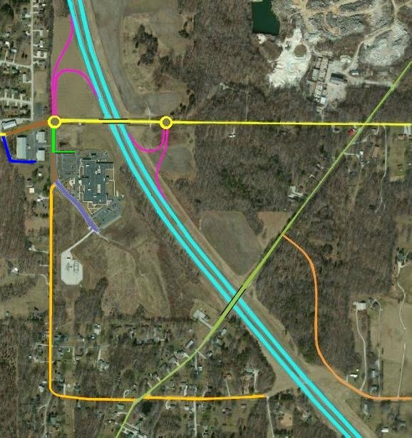
ACCESS TO ROCKPORT ROAD / THAT ROAD / SHAW ROAD
AND MONROE HOSPITAL DURING FINAL CONSTRUCTION |
Key:
- Interchange ramps
- That Rd (E of I-69)
- Shaw Rd (W of I-69)
- Fullerton Pk
- Rockport Rd
- Monroe Hospital Access
- I-69 / IN-37
- Monroe Medical Park Bv
- Reddy Way (Medical
Offices Rd)
- Construction closures
___________________________________
|
|
|
These instructions are no longer valid. They were retained for historical value.
These instructions changed six times (08/06/2017, 08/13/2017, 08/18/2017, 08/22/2017,
08/23/2017, and 09/01/2017):
- Tapp Road (north of the area shown on the map) closed just east of IN-37 / I-69 on
08/06/2017. It closed west of the highway on 08/22/2017. The detour for Tapp Road access
is IN-45 (Second Street). Fullerton Pike can be used for a detour to east Tapp Road, but
a Fullerton detour for West Tapp Road will have to wait until the approach to the west
roundabout of the Fullerton interchange is finished.
- Access to west Fullerton Pike from the interchange and from the Medical Offices Road
closed on 08/23/2017. It reopened on 09/01/2017.
- The Fullerton Pike interchange had full access to all connecting roads from 08/18/2017
to 08/23/2017.
-- The Fullerton Pike approach to the west roundabout of the interchange is
not finished.
- Traffic to Monroe Medical Park Blvd must not use west Fullerton Pike. Access to Shaw
Road was closed on 08/13/2017 and reopened on 08/18/2017. No detour was posted.
- Traffic to the Monroe Medical Offices must not use west Fullerton Pike (closed
08/23/2013). Access is now by Monroe Medical Park Blvd (opened 08/18/2017).
- The southbound exit and entrance ramps have very rough pavement height transitions.
- The southbound entrance ramp has no acceleration lane.
- The already completed Rockport Road overpass provides full access connecting That Road,
Shaw Road, Monroe Hospital, Monroe Medical Park Blvd, and East Fullerton Pike (Connection
to Monroe Hospital and Monroe Medical Park Blvd closed on 08/13/2017 and reopened on
08/18/2017).
- The roadways connecting I-69 / IN-37 to That Road and to Shaw Road are
permanently gone.
- Because Tapp Road is closed at IN-37 for interchange construction, a detour must be used
to reach the medical park on Tapp Road. Use Rockport Road from the Fullerton Pike
interchange to reach Tapp Road. An alternate detour is Second Street, Rogers Street, and
Rockport Road. These detours are posted.
- With the closure of Tapp Road on 08/22/2017, the traffic signal at Tapp Road and Leonard
Springs Road was taken down. The last traffic signal on IN-37 / I-69 should have been taken
down at the same time, but it is still up for construction truck access.
|
|
These instructions are no longer valid. They were retained for historical value.
- The Fullerton Pike interchange now has full access to Monroe Hospital.
-- DO NOT use Monroe Hospital parking lot for access between Fullerton Pike,
and Shaw Road.
-- Use of private property to bypass detours is illegal. It also disrupts hospital
operation.
- All traffic to Monroe Medical Park Blvd must use the hospital parking lot (Access
to Shaw Road was closed on 08/13/2017). No detour is posted.
- All traffic to Shaw Road must use Rockport Road. No detour is posted.
- All traffic to Rockport Road from I-69 / IN-37 must exit east on Fullerton
Pike.
- All traffic to west Fullerton Pike or the Monroe Medical Offices must use Leonard
Springs Road from Second Street to west Fullerton Pike. An erroneous detour is posted
taking people south on Rockport Road, but never telling them where to turn for Fullerton
Pike.
- Fullerton Pike is still completely closed to access west of the I-69 / IN-37
interchange. No detour is posted.
- The already completed Rockport Road overpass provides full access connecting That Road,
Shaw Road, and East Fullerton Pike (Connection to Monroe Hospital and Monroe Medical Park
Blvd closed on 08/13/2017).
- The roadways connecting I-69 / IN-37 to That Road and to Shaw Road are
gone.
- Because Tapp Road is closed at IN-37 for interchange construction, a detour must be used
to reach the medical park on Tapp Road. Use Rockport Road from the Fullerton Pike
interchange to reach Tapp Road. An alternate detour is Second Street, Rogers Street, and
Rockport Road. These detours are posted.
To go to Monroe Hospital:
- From IN-37, take the Fullerton Pike Exit. A driveway is available at the west
roundabout.
- From Rockport Road: Turn west on Fullerton Pike and follow it until you get to the
hospital (Access from Shaw Road was closed on 08/13/2017 and reopened on 08/18/2017).
- There is no access from west Fullerton Pike or Leonard Springs Road. Use Second Street
to get on IN-37 / IN-69 south and take the Fullerton Pike exit (Access reopened on
08/18/2017 through the Medical Offices Road).
- A southbound sign says to go to Monroe Hospital, take exit 115. But there are no
southbound signs telling where exit 115 is.
To leave Monroe Hospital:
- To go to IN-37 Use the north parking lot exit to enter the Fullerton Pike interchange
and then use the desired on ramp.
- To go to Rockport Road: Use the north parking lot exit to enter the Fullerton Pike
interchange. Go east on Fullerton to get to Rockport Road. Turn in the direction you wish
to go on Rockport (Access from Shaw Road was closed on 08/13/2017).
- To go to Leonard Springs Road, enter IN-37 northbound and take the Second Street
(IN-45) exit west. Turn in the direction you wish to go on Leonard Springs / Curry.
These missing connections should be completed within a few weeks.
Once the Fullerton Pike interchange is fully completed, ignore these instructions. They
will be left here to show how the odd detours worked during construction.
|
| |
| DURING EARLY CONSTRUCTION |
How you drove between certain locations during early construction:
|
| ROCKPORT / THAT / SHAW ROADS - EARLY CONSTRUCTION |
Key:
- That Rd (E of I-69)
- Shaw Rd (W of I-69)
- Fullerton Pk
- Rockport Rd
- I-69 / IN-37
- Monroe Medical Park Bv
-
Interchange construction
___________________________________
|
|
|
These instructions are no longer valid. They were retained for historical value.
- Fullerton Pike was completely closed to access with I-69 / IN-37 during the
interchange construction.
- The already completed Rockport Road overpass connected not only Rockport Road, but also
provides full access connecting That Road, Shaw Road, Monroe Hospital, and both parts of
Fullerton Pike.
- The now-closed right-turn connections on That Road and Shaw Road served as
temporary entrance and exit "ramps" until the Fullerton Pike interchange was
opened. They also provided access to Monroe Hospital.
- Once the Fullerton Pike interchange was operating, the short roadways connecting
I-69 / IN-37 to That Road and to Shaw Road were removed.
|
| |
| ACCESS TO MONROE HOSPITAL DURING EARLY CONSTRUCTION |
Key:
- That Rd (E of I-69)
- Shaw Rd (W of I-69)
- Fullerton Pk
- Rockport Rd
- I-69 / IN-37
- Monroe Medical Park Bv
-
Interchange construction
___________________________________
|
|
|
These instructions are no longer valid. They were retained for historical value.
To go to Monroe Hospital (white arrows):
- From IN-37 southbound: Continue driving past the hospital (there is no exit there).
Go under both overpasses until you get to Shaw Road. Turn right and follow Shaw Road
until you get to the hospital.
- From IN-37 northbound: Turn right onto That Road before you can see the hospital.
Make an immediate left at the end of the short connecting road. Turn left when you reach
Rockport Road. Then cross the overpass and turn right onto Shaw road. Follow it until
you get to the hospital.
- From Rockport Road: Turn west on Shaw Road and follow it until you get to the
hospital.
To leave Monroe Hospital (red arrows):
- To go to IN-37 southbound (S): Take Shaw Road. Continue following it until you get to
IN-37 southbound. Turn right.
- To go to IN-37 northbound (N): Take Shaw Road. Continue following it until you get to
Rockport Road. Turn left onto Rockport Road. Cross the overpass, turn right onto That
Road, and then turn right twice more to enter IN-37 northbound.
- To go to Rockport Road: Take Shaw Road. Continue following it until you get to
Rockport Road. Turn in the direction you wish to go on Rockport (left for Bloomington).
Now that the Fullerton Pike interchange is open, ignore these instructions. They will be
left here to show how the odd detour "interchange" worked during construction.
|
| |
| RENAMING THE ROADS SPLIT IN TWO BY I-69 |
|
The emergency dispatch and fire departments want one part of any road split into two
parts to be renamed to prevent "confusion" in dispatching police, fire, and
emergency vehicle calls.
But nobody seems to care about the confusion and expense this renaming causes to the
people and businesses located on any section of road that is so renamed:
- Having to send out change of address notices to all contacts that need to know about
the change.
- Having to pay for changes of address on driver's licenses.
- Changing telephone book entries and ads
- Having to replace stationery and address labels.
- In some cases, a business name containing the road name must be changed.
- References in professional journals and locating services must be changed.
- Signs on the sides of vehicles
- Advertising signs and billboards
- Websites
- At least three places on the roads already renamed by the I-69 project have nice
carved limestone address monuments in front of their properties. The addresses on
them contain the old names of the renamed roads. How much will replacement of these
monuments cost?
Since government is causing the expense, government should pay the expense of making
these changes.
|
|
The following roads need some kind of renaming as a result of the I-69 splitting the
road in two:
- That Road (The west end of it is already renamed to Shaw Road.)
- Vernal Pike (The east end of it is now renamed Fountain Drive.)
- Medical Offices Road (Now renamed Reddy Way.)
- Acuff Road (The west end of it has been totally removed.)
- Connaught Road (May totally disappear as a road name, becoming access roads.)
- Wylie Road (Two segments separated since IN-37 was built in the 1970s)
- Wayport Road (3 pieces)
- Sparks Lane (West end on maps may be just a driveway)
- Bryant's Creek Road (Two long segments separated since IN-37 was built)
- Pine Boulevard (West end has only one building)
|
|
Vernal Pike presented an interesting problem, because the resulting road layout has
a three-way intersection with all three roads being Vernal Pike. But there were several
problems with any possible naming scheme:
- Renaming the entire portion of Vernal Pike east of I-69 changes dozens of
addresses for street name.
- Renaming the entire portion of Vernal Pike west of I-69 changes even more dozens
of addresses for street name.
- Renaming Crescent Road to Vernal Pike can create duplicate house numbers and block
numbering on Vernal Pike unless house numbers on Crescent Road are changed.
- If house numbers are changed on Crescent Road, then the new house numbers and block
numbering on Crescent Road (if renamed Vernal Pike) will duplicate old house numbers and
block numbering on the old portion of Vernal Pike (renamed something else) between
Indiana 37 and Crescent Road.
- A new name will be needed for the old portion of Vernal Pike between Indiana 37
and Crescent Road if any plan but the renaming of the west part of Vernal Pike is
adopted. The page author suggests extending the name of Nuckles Road.
What they did was rename the entire portion of Vernal Pike east of I-69 to be Fountain
Drive.
|
|
More logistics problems have surfaced:
- The State Police Post was moved from the IN-45 / 46 bypass at Fee Lane when that
bypass was widened to 4 lanes. It was put on Packinghouse Road to have close access
to the state highway system. But Packinghouse Road is now 1.3 to 2.7 miles away
from the state highway system (depending on direction).
- The Indiana State Highway Garage on Prow Road was formerly just a small distance
(less than a mile) from both Indiana 46 and Indiana 37. Now it has been disconnected
from both highways. The shortest distance for big trucks (not using residential roads)
is over 2 miles to IN-46 and is nearly 4 miles to IN-37.
- Large trucks have obstructions trying to reach Fountain Drive and West 11th Street.
All of the possible routes have obstacles after the construction is finished:
- Fountain Drive (formerly Vernal Pike) no longer has access to
I-69 / IN-37.
- Adams Street has a low clearance railroad bridge and a hump railroad crossing.
- Part of Fountain Drive has either a low clearance or a hump crossing to get to
it.
- 11th Street has a low clearance railroad bridge at Fairview Street.
- Monroe Street has a medium-sized roundabout at 17th Street.
- Crescent Rd (the obvious choice) is posted NO TRUCKS.
- People going to and from Monroe Hospital had a changing circuitous route to follow
during the construction.
-
Mistakes made since the State of Indiana took over the project on 07/31/2017
The following are places where things were done wrong since
07/31/2017
- Signs that indicate safe maneuvers are left in place while lanes
needed for those maneuvers are closed, making them impossible. Example: The ramp is
an added lane and is signed with added lane signs. But workers cone off one lane
without covering the added lane signs and providing a yield sign. THIS IS
DANGEROUS.
- There are two places where they have chosen to close the left lane
at the same place where an entrance ramp is merging from the right. Signs indicate
the closure of the left lane as a need to merge right where entering traffic from the
ramp can see them. Dropping lanes on both sides at the same place is also discouraged.
THIS IS DANGEROUS.
- When lanes are shifted, the old markings are left in place. Only the
traffic cones and barrels are moved.
- In other cases when lanes are shifted, the old markings are left in
place, but new ones are added too. The traffic cones and barrels are moved, but too
many drivers follow the wrong marks.
- Signs saying TO 37 are still posted pointing to side roads that no
longer have any access to IN-37 and haven't had any access for months.
- Where markings were changed, they used stick-down tape lines. The
lines did not stay where they were supposed to be, but came loose and wandered. They
have not removed the erroneous lines.
- The southbound entrance ramp from IN-48 has no acceleration lane, but
does have adequate warning of its absence. But this is still DANGEROUS to traffic.
It is hard to see backwards in some vehicles at the end of a ramp.
- The state is not obeying the promise to keep two lanes open in each
direction that the private contractors had to obey. Multiple parts of IN-37
have only one lane open in each direction.
- Detours were not posted for getting to Shaw Rd, Monroe Medical Park Bv,
or Monroe Medical Offices in August and September.
- Ways to get to Shaw Rd and Monroe Medical Park Bv kept changing.
- An erroneous detour was posted for getting to west Fullerton Pk. It
sent people to Kirksville.
- People trying to get to Monroe Medical Offices (on Monroe Medical Park
Bv) saw signs for Medical Park (on Tapp Td) and followed an erroneous detour.
- The traffic Signal at IN-37 and Tapp Road was wrongly set to give a
very short light for southbound IN-37, causing traffic backups. This was fixed.
- A sign on southbound IN-37 directs people to turn off at Exit 115 for
Monroe Hospital. But no other signs identify where Exit 115 is. This has been
fixed.
- A sign on southbound IN-37 telling people to turn off for
Monroe Hospital had no arrow telling which way to go. This has been fixed.
- Very rough changes in pavement level are on the southbound exit ramp
to Fullerton Pike, the southbound entrance ramp from Fullerton Pike and the connection
from west Fullerton Pike to the roundabout. These could damage vehicles. This has been
partially fixed.
- The southbound entrance ramp from Fullerton Pike has no acceleration
lane and no adequate warning of its absence, since the same signage is used at other
ramps with short acceleration lanes. This has been fixed.
- A sign on northbound IN-37 directs people to a not-yet-constructed
Exit 116 for Tapp Road. This has been covered.
- Three signs on southbound IN-37 contradict each other on detours:
- TAPP ROAD CLOSED DETOUR FULLERTON PIKE
- DETOUR AHEAD FULLERTON PIKE (this sign was removed March 2018)
- DETOUR TAPP ROAD (right arrow to IN-45 ramp)
This has been erroneous since October 2017.
- Many of the construction and detour signs put up by the private
management before the state took over are still in place, though they are now
erroneous.
- Use of directional arrows on detour signs is not uniform. At one exit,
one sign has a slanted turn arrow and another sign has a horizontal turn arrow - for
the same turn.
- Some changeable message signs are not aimed to be seen for more than 5
seconds.
- Some changeable message signs are totally dark due to cloudy days not
charging the batteries.
- One changeable message sign has one letter panel totally dark.
- One changeable message sign had "yield" spelled YEILD. This has been
removed.
- Some detours are several miles long to the nearest point where cars
could make U-turns. They are sparsely signed. What large trucks are supposed to do is
not disclosed.
- A merge sign for a merge from the right is on the left side of the
highway.
- A sign for lane shifts is still in place where the lane shifts have
already been removed.
- On 09/21/2017 they covered the traffic signals at Tapp Road preparatory
for removing it. Then on 09/22/2017 they uncovered them again. They finally removed
them in early November.
- They removed the traffic signals at Tapp Road in early November, but
the SIGNAL AHEAD signs for northbound traffic are still there.
- Signs tell drivers to get into the left lane for I-69 and the right
lane for IN-37. Then they closed the left lane for more work, undoing what the signs
say to do.
- The eastbound lane on That Road has no shoulder where it used to connect
to IN-37. Instead there are barricades flush with the edge of the road. The shoulder
should be restored. They replaced the barricades with traffic cones in early November,
but they have not yet replaced the shoulders. This was fixed in January 2018.
- Fumes emitted from under a tent under the Second St (IN-45) bridge were
causing car engines with oxygen sensors to misfire after the cars passed under the
bridge. This is now gone. In November they put the tent under the Third St (IN-48)
bridge, causing the same problem.
- A westbound lane on Third St was closed just west of the
I-69 / IN-37 interchange on 05/09/2018. Traffic backed up on Westbound Third St all
the way to Adams St. But traffic did not back up substantially on either of the
interchange exit ramps.
The problem was that the ramp signals were coordinated to each other:
- The east ramp signal releases northbound ramp traffic onto the bridge. It fills up
the bridge space between the two signals. The west ramp signal turns green for
westbound traffic during this period and starts to empty the space between the ramp
signals.
- When the east ramp signal turns green for westbound traffic, the bridge is full and
there is no room for more cars between the ramp signals. By the time the east end of
the bridge empties out, both signals turn red for westbound traffic. Only two or three
cars can enter the bridge from the east on each cycle.
- The next east ramp phase is for eastbound left turns. This stops westbound traffic,
keeping it from entering the empty part of the bridge. Very little traffic was turning
left.
The signals were not traffic actuated because construction had destroyed the loop
detectors.
When both lanes on the bridge are open, there is room for the traffic to pass
through without backing up.
They should have adjusted the signals so westbound traffic could get through.
- The state plan to complete the project "on time at reduced cost"
closes more lanes of traffic for longer periods than the privately-run plan would have
done. Traffic backs up daily at rush hour.
- The state plan to complete the project "on time at reduced cost"
might not have provided the two straight-ahead lanes and two turn lanes for eastbound
IN-45 at the northbound IN-37 / I-69 ramps that were in the private plan.
Update: The state is now constructing those lanes.
- The state plan to complete the project "on time at reduced cost"
has traffic backing up on Second Street from the interchange all the way to Walnut Street.
It also has traffic backed up on IN-48 from Ivy Tech to the interchange. These
backups are at times other than rush hour.
- The traffic signals at Second Street and the southbound ramps of
IN-37 and I-69, at Second Street and Liberty Drive, at Second Street and Basswood Drive,
at Third Street and Gates Drive, at Third Street and Wynndale Drive, and the southbound
IN-37 ramps at Third Street all have circular greens over exclusive left turn lanes that
violate the MUTCD.
- A circular green is not allowed to be in a signal face placed over or in front of
an exclusive left turn lane.
- UPDATE 08/10/2018: The signals at the six intersections with the wrongly installed
5-section faces now have Flashing Yellow Arrows instead. The temporary construction
signals violated the MUTCD to reduce the cost and amount of labor needed to convert
them.
- UPDATE 08/13/2018: The signal on the Sam's Club driveway on the Second Street
interchange has a flashing yellow arrow face and two 3-section thru signal faces.
This violates the MUTCD because there is only one lane open and the left green arrow
shows with circular red at the same time on a single lane approach.
- The wrong merge signs appear at some entrance ramps. Signs for a
lane-ends merge are posted where there is an added-lane merge.
There is no way a self-driving car could correctly navigate this
construction zone.
Democrats repeatedly did things that caused the private contracts to fail
and to lower the values of the private bonds. They did this because they oppose all
privatization. They also oppose building I-69, but can't stop that.
-
Through lack of coordination between state, county and city governments,
a nightmare of interlocking road closings beginning on 05/10/2018:
CONSTRUCT-LOK 2018
There is no unobstructed way to get between anywhere west of the IN-37
bypass and downtown Bloomington.
The county and city made their contracts expecting I-69 to be completed
in 2017.
This reminds me of an old song (with slightly altered lyrics):
"And they tell me, over and over and over and over again...
that you can't get there. The road is under construction."
Both the State Police Post and the Highway Garage may have to be moved. The Monroe
Hospital problem was fixed when the Fullerton Pike interchange was finished.
|
| |
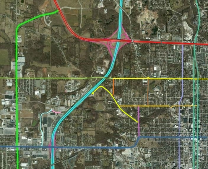
| TRAVEL DISTANCE CHANGES |
| How much farther to drive between certain locations:
In many cases, the closest route to take is not obvious. These maps show the best
alternate routes for drivers who used to use these roads. The column labeled
"DISTANCE INCREASE" shows how much farther the driver must drive to use
that connecting route. A negative value indicates that the new route is closer than the
old route:
|
| VERNAL PIKE / FOUNTAIN DRIVE |
Key:
- Interchange ramps
- IN-45 / IN-46
- Crescent Rd
- 11th St
- 17th St
- Fountain Dr (E of I-69)
- Vernal Pk (W of I-69)
- Curry Pk
- Walnut St / College Av
- I-69 / IN-37
- IN-48 / 3rd St
- Kinser Pk / Rogers St
- Adams St
- Whitehall Crossing Bv
- Gates Dr
- Monroe St
________________________
Monroe County has voted to
rename the eastern part of
Vernal Pk. to be Fountain Dr.
|
|
| ROAD 1 | ROUTE | ROAD 2 | DIST
INCR |
| Vernal Pike (W @ Industrial Dr) |
↔ Crescent Rd ↔ |
Fountain Drive (FKA Vernal Pike E @ 11th St) | -0.1 mi (less) |
| Vernal Pike (W @ Industrial Dr) |
↔ Curry Pk ↔ 3rd St ↔ |
IN-37 (S @ IRR Bridge) | 1.2 mi |
| Vernal Pike (W @ Curry Pk) |
↔ Curry Pk ↔ 3rd St ↔ |
IN-37 (S @ IRR Bridge) | -0.9 mi (less) |
| Vernal Pike (W @ Industrial Dr) |
↔ Curry Pk ↔ IN-46 ↔ |
IN-37 (N @ Arlington Bridge) | 2.7 mi |
| Vernal Pike (W @ Curry Pk) |
↔ Curry Pk ↔ IN-46 ↔ |
IN-37 (N @ Arlington Bridge) | 0.5 mi |
| Fountain Drive (FKA Vernal Pike E @ 11th St) |
↔ Adams St ↔ 3rd St ↔ |
IN-37 (S @ IRR Bridge) | 0.5 mi |
| Fountain Drive (FKA Vernal Pike E @ 11th St) |
↔ Crescent Rd ↔ Vernal Pk ↔ Curry Pk ↔
3rd St ↔ |
IN-37 (S @ IRR Bridge) | 1.7 mi |
| Fountain Drive (FKA Vernal Pike E @ 11th St) |
↔ Crescent Rd ↔ 17th St ↔ Kinser Pk ↔ IN-46 ↔ |
IN-37 (N @ Arlington Bridge) | 1.3 mi |
| Fountain Drive (FKA Vernal Pike E @ 11th St) |
↔ Adams St ↔ 3rd St ↔ |
IN-37 (N @ Arlington Bridge) | 2.5 mi |
| |
| WHITEHALL CROSSING BOULEVARD |
| ROAD 1 | ROUTE | ROAD 2 | DIST
INCR |
| IN-37 (Southbound @ IN-45 merge) |
(Original is one way) → 3rd St → Gates Dr → |
Whitehall Crossing Bv (@ Gates Dr) | 1.1 mi |
| Whitehall Crossing Bv (@ Gates Dr) |
(Original is one way) → Gates Dr → 3rd St → |
IN-37 (Southbound @ IRR Bridge) | 0.0 mi |
| |
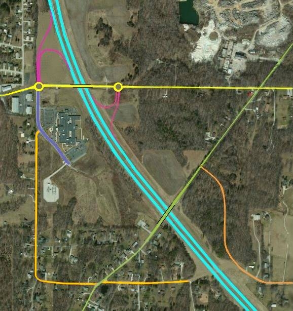
| ROCKPORT ROAD / THAT ROAD / SHAW ROAD |
Key:
- Interchange ramps
- That Rd (E of I-69)
- Shaw Rd (W of I-69)
- Fullerton Pk
- Rockport Rd
- I-69 / IN-37
- Monroe Medical Park Bv
________________________
Monroe County has voted to
rename the western part of
That Rd to be Shaw Rd.
|
|
| ROAD 1 | ROUTE | ROAD 2 | DIST
INCR |
| Shaw Rd (FKA That Rd W @ Rockport Rd) |
↔ Rockport Rd ↔ |
That Rd (E @ Roy Bailey Dr) | 0.2 mi |
| Shaw Rd (FKA That Rd W @ Southeast Ln) |
↔ Rockport Rd ↔ |
That Rd (E @ Roy Bailey Dr) | 0.7 mi |
| That Rd (E @ Roy Bailey Dr) |
↔ Rockport Rd ↔ Fullerton Pk ↔ |
IN-37 (S @ I-69 Bridge) | 1.6 mi |
| That Rd (E @ Roy Bailey Dr) |
↔ Rockport Rd ↔ Shaw Rd ↔
Monroe Medical Park Bv ↔ Fullerton ↔ |
IN-37 (S @ I-69 Bridge) | 1.9 mi |
| That Rd (E @ Roy Bailey Dr) |
↔ Rockport Rd ↔ Fullerton Pk ↔ |
IN-37 (N @ Tapp Rd) | 0.4 mi |
| That Rd (E @ Roy Bailey Dr) |
↔ Rockport Rd ↔ Shaw Rd ↔
Monroe Medical Park Bv ↔ Fullerton ↔ |
IN-37 (N @ Tapp Rd) | 0.8 mi |
| Shaw Rd (FKA That Rd W @ Southeast Ln) |
↔ Monroe Medical Park Bv ↔ Fullerton ↔ |
IN-37 (S @ I-69 Bridge) | 1.6 mi |
| Shaw Rd (FKA That Rd W @ Southeast Ln) |
↔ Rockport Rd ↔ Fullerton Pk ↔ |
IN-37 (S @ I-69 Bridge) | 1.9 mi |
| Shaw Rd (FKA That Rd W @ Southeast Ln) |
↔ Monroe Medical Park Bv ↔ Fullerton ↔ |
IN-37 (N @ Tapp Rd) | 0.4 mi |
| Shaw Rd (FKA That Rd W @ Southeast Ln) |
↔ Rockport Rd ↔ Fullerton Pk ↔ |
IN-37 (N @ Tapp Rd) | 0.7 mi |
| Shaw Rd (FKA That Rd W @ Rockport Rd) |
↔ Monroe Medical Park Bv ↔ Fullerton ↔ |
IN-37 (S @ I-69 Bridge) | 1.1 mi |
| Shaw Rd (FKA That Rd W @ Rockport Rd) |
↔ Rockport Rd ↔ Fullerton Pk ↔ |
IN-37 (S @ I-69 Bridge) | 1.5 mi |
| Shaw Rd (FKA That Rd W @ Rockport Rd) |
↔ Monroe Medical Park Bv ↔ Fullerton ↔ |
IN-37 (N @ Tapp Rd) | 0.1 mi |
| Shaw Rd (FKA That Rd W @ Rockport Rd) |
↔ Rockport Rd ↔ Fullerton Pk ↔ |
IN-37 (N @ Tapp Rd) | 0.5 mi |
| |
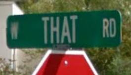 Visitors and new residents always ask the question, "Why do you have a road named
'That Road' here?" The name conjures up the thought of an Abbott & Costello
skit.
Visitors and new residents always ask the question, "Why do you have a road named
'That Road' here?" The name conjures up the thought of an Abbott & Costello
skit.