|
PRESS FALLACY #1 "Air traffic controllers should be in continuous touch with airliners and each other." |
Several factors combined to keep the air traffic controllers from noticing that anything was wrong:
- The plane disappeared at the time it was supposed to be handed off from the Malaysia ATC (Air Traffic Control) to Vietnam ATC. The pilots signed off to Malaysia, but never contacted Vietnam.
- Malaysia ATC and Vietnam ATC are not normally in continuous contact with each other.
- The plane was in an area where RADAR contact was expected to be lost.
There is normally no RADAR coverage over large bodies of water. A RADAR set on the ground has a maximum useful range of 100 to 200 miles, depending on the altitude of the plane.
|
PRESS FALLACY #2 "There should be RADAR coverage of the airspace over the entire earth." |
RADAR must use a line-of-sight kind of radio waves. Due to the curvature of the earth, a RADAR set on the ground has a maximum useful range of 100 to 150 miles. Anything farther out over the ocean cannot be tracked without having a RADAR set on or over the ocean. That would mean the expense of having RADAR sets on ships or planes put there and manned for the purpose.
The following table shows the minimum altitude (rounded) a RADAR set on the ground (near sea level) can detect an aircraft. Below that altitude, the earth's curved surface hides the aircraft from the RADAR:
| Distance to Object | m | Minimum Altitude of Object | |||
|---|---|---|---|---|---|
| Miles | Km | Feet | Miles | Km | |
| 50 | 90 | 1,500 | 0.3 | 0.5 | |
| 100 | 180 | 6,500 | 1.2 | 2.2 | |
| 150 | 270 | 15,000 | 3 | 5 | |
| 200 | 360 | 26,000 | 5 | 9 | |
| 250 | 450 | 40,000 | 7.5 | 14 | |
| 300 | 550 | 80,000 | 15 | 27 | |
|
PRESS FALLACY #3 "RADAR should use radio that follows the earth's curvature." |
Most radio waves that can bend over the horizon can also bend around an aircraft without being reflected by it. This makes those radio waves useless for RADAR.
There are RADAR sets with longer range. These sets use frequencies that can follow the curvature of the earth or frequencies that bounce off the ionosphere. But these sets do not have a normal RADAR display on a screen. They are manually aimed to cover what is called a tile of the surface of the earth. The only value they report for objects within the tile is distance. Such RADAR sets are designed more to register the presence of objects, rather than find their exact location.
These sets are not as dependable as other RADARs, because they are affected by sunspots, the state of the ionosphere, weather conditions, and other factors. Such disturbances can make the RADAR fail to detect objects, cause false detections, or change the distance the RADAR covers.
The Jindalee Operational Radar Network (JORN) is the Australian Over The Horizon RADAR (OTHR) system. Project Jindalee was the name of the military project that created this system. It has a normal range of 1800 miles (3000 Km), using three sets operating on frequencies that bounce off the ionosphere.
The sets are at Longreach (in Queensland), Laverton (in Western Australia), and Alice Springs (in the Northern Territory). The Laverton set can be aimed to various directions within a range of 180 degrees. The other two have aiming ranges of 90 degrees. The centers of the aiming ranges of all three sets are in the direction of China.
The multiple antennas at each station are manually aimed for a single tile. They do not automatically sweep around the compass as normal RADAR sets do. These sets detect only metal aircraft and ships. They do not work with transponders.
Unfortunately, the Australians had all of the antennas aimed to the northeast, to detect refugee boats off the northern coasts of Australia. The intended flight path of MH370 was outside JORN's normal range, so JORN would have not been useful if the plane had crashed on its intended route. They didn't know that JORN was needed to the west until days after the plane disappeared, when the Inmarsat data indicated that MH370 went south. The Laverton set could have registered the presence of MH370, but it could not have tracked its actual path. It would report only the distance from Laverton and when it entered and left the tile.
Also note that the antennas of JORN are manually aimed by technicians. If they had known at the time of the disappearance that JORN was needed, it would have taken hours to aim and calibrate the antennas.
Several factors combined to keep anyone from missing MH370:
- Vietnam ATC assumed that MH370 might have taken off late.
- Malaysia ATC didn't know that Vietnam was never contacted by MH370 until Vietnam called them.
- A tech used the wrong computer page that showed the projected location of MH370 instead of the actual location. This made Malaysian Airlines think it was still in contact with MH370 through ACARS (Aircraft Communications Addressing and Reporting System).
- Malaysian Airlines erroneously told Malaysia ATC it was still in contact with MH370 through ACARS. This error was not corrected until over two hours after the MH370 transponders quit working.
He switched to the projected location page because the actual location page quit working.
He thought the page quit working due to computer trouble.
The page quit working because the ACARS signal was no longer being received from MH370.
The plane was expected to disappear from RADAR at about that time. It was moving beyond the range of both ATC and military RADAR as it crossed over an open stretch of ocean.
|
PRESS FALLACY #4 "Only one unidentified blip was on the Malaysian military RADAR: It was MH370." |
An unidentified target on military RADAR was nothing unusual:
- MH370 was not the only unidentified target on the RADAR.
- There were hundreds of unidentified targets on the RADAR. One more would not be noticed.
- It is hard to keep track of which unidentified target is which.
- No targets were seen acting in a hostile manner.
A target is usually said to be acting in a hostile manner if it does any of the following:
- Flies toward or over a location where flying is prohibited (e.g. a military base).
- Flies toward the Petronas Twin Towers.
- Flies in an evasive way to confuse RADAR operators.
- Flies at fighter attack speeds.
There are many unidentified targets flying over every country at any time. MH370 was lost in a sea of unidentified blips.
Every private aircraft that is in the air is an "unidentified target."
Most of the little Cessna-style planes, and many corporate planes and helicopters, do not have transponders.
Neither the military controllers nor the commercial air traffic controllers keep track of private flights, other than keeping the planes they do control from crashing into them.
There are several ways a controller deems an unidentified target to warrant attention:
- It acts in a hostile manner (see above).
- The target seems to correspond to a visual sighting reported to the RADAR operator.
- The target is doing things a normal aircraft cannot do.
The UFO target might be a misidentified private aircraft.
Primary RADAR is RADAR that displays every echo returned to it as a blip. It detects aircraft by detecting a pulse from the RADAR set that is reflected from the metal parts of the aircraft. The aircraft needs no special equipment to be detected other than being made of metal.
Skin-paint RADAR and primary RADAR are two names for the same thing.
Secondary RADAR is a part of the RADAR system for commercial and military aircraft that identifies the aircraft to any RADAR set so equipped, and also reports the aircraft's altitude. A transponder device on the aircraft receives the RADAR pulse and returns the plane's identity and altitude.
A transponder is a part of the RADAR system for commercial and military aircraft that identifies the aircraft to any RADAR set so equipped, and also reports the aircraft's altitude. The transponder on the plane receives the RADAR pulse and returns the information.
Automatic Dependent Surveillance Broadcast (ADS-B) is a passive system that periodically transmits the plane's GPS position. One of these was installed on MH370.
|
PRESS FALLACY #5 "The military can get a jet into the area in a minute or two." |
There are several reasons:
- They assumed the flight had crashed.
- Because they didn't know which blip was MH370, they wouldn't have known where to look.
- By the time the flight was known to be missing, it had already left the range of Malaysia military RADAR.
- Malaysian military RADAR had no targets that appeared to be unusual or threatening.
- In peacetime, it can take up to an hour to scramble a jet. Then it has to get from wherever it took off to the area where it is needed.
Because the plane was assumed to have crashed, they sent search planes, not interceptor jets, into the expected crash area northeast of Kuala Lumpur.
In times of peace, pilots don't sit in the cockpits of jets waiting for a scramble.
- They have to get a pilot to the jet fighter.
- They might have to fuel up the fighter.
- They have to go through the engine startup procedure.
- They have to get other air traffic out of the way of the jet takeoff.
Then the fighter has to get from wherever it took off to wherever it is needed. At 600 mph, a 100-mile distance takes 10 minutes.
|
PRESS FALLACY #6 "The military had the track of MH370 available in real time." |
The path of the flight was reconstructed later:
- The military had people do a painstaking reconstruction of the paths of all of the unidentified aircraft.
- They used the records kept of the contents of the RADAR screens.
- They might have used a computer to speed up the work.
- They reconstructed the paths of all of the private planes first. Remaining blips were MH370.
- They were able to reconstruct two disconnected paths of MH370.
- The path farther west was reconstructed later than the path farther east was.
Indonesia has the same RADAR problem Malaysia has. If it had been detected, it would be one blip in a sea of hundreds.
Indonesia would have had to reconstruct it in the same way that Malaysia did.
From the projected flight path obtained from the Malaysia reconstruction, MH370 stayed out of range of Indonesia military RADAR.
ACARS (Aircraft Communications Addressing and Reporting System) is a satellite based system where systems on the aircraft report back to the aircraft owner via satellite. It reports through the Inmarsat approximately once every half hour. It also handles phone calls between the airplane and the ground.
Inmarsat (International Maritime Satellite) is a global system of communications satellites based in the United Kingdom. It uses geosynchronous satellites to provide various kinds of communications, including ACARS.
A geosynchronous satellite is a satellite that orbits the earth at the same angular rate that the earth rotates at. It orbits the earth once every day. Therefore, the satellite always stays over the same longitude as the earth rotates with it.
This is the Inmarsat handshaking exchange that periodically checks the connection. The Inmarsat asks the transceiver on the plane if it is still active. If it is, the transceiver responds, also sending some information about engine performance.
Either a failure deprived them of power, or someone turned them off. But note that the Classic Aero transceiver did not stop working, indicating that the plane was still flying.
Note that the Classic Aero transceiver is connected to power in a maintenance bay, not in the cockpit. Circuit breakers for the transponder, ADS-B, and ACARS are in the cockpit.
|
PRESS FALLACY #7 "Pilots should not be able to shut off or change settings on transponders." |
There are several reasons:
- When the aircraft is on the ground, ATC does not want the aircraft to appear on RADAR.
- Settings must be changed when the aircraft starts a new flight.
- If a failure makes a unit send out electronic gibberish, it must be shut off to let the system work for other aircraft in the area.
- If a unit draws too high a current, it must be shut off to protect the aircraft's electrical system.
Airline pilots are considered to be trusted people, so they are trusted with these critical units.
|
PRESS FALLACY #8 "A hijacker would have had to hide MH370 from RADAR." |
Yes. There are several different ways:
- They could have turned off the transponder and followed closely behind another airliner.
- They could have set the transponder to the same code that another flight has. The RADAR set would remove any duplicate transponder return as a multiply reflected RADAR beam path.
- They could have made up a new transponder setting, and answered ATC calls as an unscheduled flight (such as an extra flight to relieve overcrowding).
- They could fly too low to be on RADAR.
But it was unnecessary for a hijacker to hide MH370 from RADAR, because it looked like a private plane with the transponder off.
The Malaysia RADAR reconstruction and the Classic Aero pings show a flight path that no transponder RADAR track followed.
There are two kinds of imaging satellites:
- Geosynchronous satellites, which have a high orbit of 26,199 mi (42,164 km) from earth, are far away from the area being photographed, but can take as many pictures as needed of the same area.
- Lower altitude satellites take much better pictures, but those using the satellite have to wait until the part of the earth where the image is wanted passes under the orbit when the satellite is there. This can take days, or even weeks.
|
PRESS FALLACY #9 "Satellites can be sent to the locations where they are needed for disaster work." |
|
PRESS FALLACY #10 "Satellites can hover over any spot on earth as long as they are needed." |
Nobody can "send" existing satellites anywhere. All satellites must orbit the earth, with the center of the earth as one focus of the orbital ellipse.
There are so many satellites now that any new satellite orbit has to be carefully chosen to prevent a collision with an existing satellite. Otherwise, satellites will collide, putting even more objects (the pieces of wreckage) into orbit.
Most satellites have no rocket fuel at all to alter their orbits. They must stay in the orbits they were launched into.
Some satellites have enough fuel to get out of the way of meteors or space junk, or slightly adjust their orbits. Many satellites can rotate in place using electric gyroscopes, but can't change their orbits.
But no satellite has enough rocket fuel to be sent to multiple places as needed. Those who use satellites have to use them in the orbits they are already in. Even the space shuttle could not change orbits more than one or two times per flight, and those changes had to be minor.
Only a geosynchronous satellite can stay over some part of the earth, and that part must be over the equator. A geosynchronous satellite either stays near the equator, or swings north and south of the equator by the same number of degrees of latitude.
All other satellites must appear to circle the earth as seen by people on the ground. Those that pass over an area of interest pass over it only once in a while.

The image at right shows the locations of all working satellites, space stations, all defunct satellites, and large space junk, captured a few months before the MH370 disappearance. Each one of those objects is orbiting the earth, with the center of mass of the earth being one focus of the ellipse of each object's orbit. The visible horizontal ring a large distance away from earth, but over the equator is the set of geosynchronous satellites. All of the satellites that average that distance are geosynchronous. The diagram shows how hard it would be to put a satellite where it "is needed now", and why fully steerable satellites are not a good idea. |
China changed the aiming of the cameras on their satellites to photograph the needed areas. Since the aiming of a camera doesn't need any fuel (just electricity from the solar panels), the cameras can be aimed as often as they wish to aim them.
|
PRESS FALLACY #11 "The objects in the satellite images had to be wreckage from MH370." |
Most of them were not wreckage. They were:
- Reflections of the sun from the ocean surface
- Reflections from waves into the satellite cameras
- Reflections of the sun off a shallow bottom.
- Debris from a typhoon (southern hemisphere hurricane) that went through the area shortly after MH370 disappeared
- Other debris that was later found by searchers (and was determined to not belong to MH370 - much of it was lost fishing equipment)
Most of it was commercial fishing equipment that was washed overboard or snagged in the sea.
They also found a few shipping containers that had been lost from container ships.
We have to remember that there was a typhoon (southern hemisphere hurricane) in the area shortly after MH370 disappeared. That probably put a large amount of junk in the water.
They have not yet been identified. But they were ruled out as being any part of MH370 or its cargo. They might have been wreckage from shipping containers or their contents.
They chemically analyzed samples of oil from each slick. They found compositions that should not have been present on MH370. Most of them were spills of fuel oil made for ship engines.
An ELT (Emergency Locator Transmitter) is a transmitter activated by the g-forces of a plane crash. It then sends a homing signal so rescuers can find the crash location.
|
PRESS FALLACY #12 "Radio will work under water." "This includes GPS units, cell phones, and ELTs, as long as the electronics stay dry." |
There are several possible reasons why the ELT signals were not received:
- The plane did not crash, so no g-forces were there to activate the transmitters.
- The plane crashed in water. Radio waves can't pass through water, so nobody can receive them.
- The plane soft-landed on water and then sunk. The g-forces were probably too light to activate the transmitters. If the transmitters had been activated, they were under water, so nobody could receive them.
- The plane landed somewhere unknown. No g-forces activated the transmitters.
- The plane crashed with such force that all of the transmitters were destroyed.
- The ELT in the plane might have been the older type that is no longer monitored by satellites.
- The batteries on the ELT might have run down due to lack of maintenance.
ELTs are usually not detected when a plane crashes into water unless the plane remains afloat.
|
RADIO WON'T WORK UNDERWATER Note that radio waves can never pass through any electrical conductor. Each electrical conductor acts like an antenna that picks up the signal. The conductor receives the radio wave and shorts it out. The radio wave does not travel beyond the conductor unless the conducting object is very small. Enough of the radio wave gets past a small object to be received beyond it. This is why radios don't work inside metal buildings and why people have to leave metal buildings to use their cell phones. Buildings with steel framework create shadow areas where radios and cell phones don't work. Many radio frequencies can't pass through metal window screens or metallized glass. Water (especially salt water) is a good enough conductor to block radio waves. The strength of the signal passing through water is increasingly attenuated with the distance it must pass through water. After a few feet, the signal is undetectable. Salt water attenuates radio waves much more than fresh water does, and dirty fresh water attenuates more than pure fresh water does. |
|
PRESS FALLACY #12 "Radio will work under water." |
There are several possible reasons:
- If the plane landed or crashed in water, the signals can't get out. Radio waves can't pass through water.
- The plane didn't fly near any cell towers over most of its route. A cell tower is needed to receive cell phone signals.
- Cell phones placed in airplane mode do not try to connect to cell towers, WiFi, and other services. They remain quiet. Passengers were expected to put their cell phones in airplane mode and make calls through the ACARS phone provided.
One cell phone was detected by a cell tower, but this was not discovered until years later. Reconstruction shows a cell tower on Penang briefly connected to co-pilot Fariq Abdul Hamid's cell phone. He had not placed his phone in airplane mode, or this would not have happened. The connection was brief because the plane quickly went out of range of that cell tower.
They used the data of the time the Classic Aero ping was sent and the time the answer was received as a form of RADAR to find the distance of MH370 from the satellite. They used the maximum range of the plane to determine the ends of the search arcs.
This has never been done before.
They also found that they could find out the frequency of the received answer, and compare it to the expected frequency. Thus, they got a form of Doppler RADAR. They were then able to combine the Doppler shifts with the expected periodic movements of the satellite to narrow down the search area.
This also has never been done before. But they tested it on six other 777 flights on the same day.
The satellite moves a few miles back and forth in all three dimensions. There are two reasons this happens:
- It takes a lot more fuel to make it perfectly stationary over the equator.
- They can fit several geosynchronous satellites into the same area by letting them seem to circle a common point, as seen by someone on the ground on the rotating earth.
There are several places where the measurements could be wrong:
- The Inmarsat system was not intended to do this. There might be some unknowns that were not allowed for in the analysis.
- There might be an unexpected delay in the return of the Classic Aero ping caused by ACARS being off, as the transceiver tries several times to contact it.
- If the electrical system had a fault in it, the returned Classic Aero ping might be sent at an altered frequency.
But note that the locations derived from the Classic Aero pings closely mimic the flight plan found in Capt. Zaharie Ahmad Shah's homemade flight simulator (see below).
A black box is an aircraft flight recorder that is used in the event of a crash to reconstruct what happened. They are designed to withstand almost all crashes.
Each commercial aircraft carries two black boxes (which are actually painted fluorescent orange). One is the flight recorder, which records information about the motions of the plane and the positions of the controls. The other is the cockpit voice recorder, which records everything that was said and every sound that occurred in the cockpit.
Why is it called a black box? This comes from the type of engineering problem where a device with unknown internal properties is referred as a black box and the engineer is supposed to deduce what is in the box.
A ULB (Underwater Locator Beacon) is a device activated by water that is attached to each black box of an aircraft. If the airplane crashes or lands in water, the ULB sends out a continuous series of sound pulses (sonar pings) until its internal battery dies.
The ULBs in MH370 were designed to send a ping at 37.5 KHz once per second. This is above the range of human hearing. It was selected because it can go farther in water, and because there are few natural or man-made sounds at that frequency. A special sonar receiver is needed to detect the pings.
The battery of a standard ULB is required to have an expected life of at least 30 days. But this can be shortened by improper storage of the batteries.
An underwater pinger is a ULB.
|
PRESS FALLACY #12 "Radio will work under water." |
The ULB works on sound, not radio. Radio waves can't pass through water, so the unit can't receive any GPS. It also can't send radio, and it can't send complicated information through sound. It would have to use Morse code or acoustic-coupler modem tones to send any information, which takes time.
The purpose is finding the black box in wreckage, not finding the aircraft in a vast ocean. The range of the sound is at most 2 miles (3.2 Km), so when it is heard, the search area is very close.
A towed pinger locator is a sonar listening device designed to pick up the pings from the ULB. It is towed behind a ship at a depth where it can pick up the pings easier. The idea is to tow it below the thermocline (a horizontal layer of temperature change in the ocean that reflects sound), so it detects sounds coming from the bottom. The Phoenix International TPL-25 is the unit in use.
Ocean Shield is the Australian ship used to tow the towed pinger locator.
They wouldn't have known where to start searching. With a maximum range of only 2 miles, they would have been wasting their time.
The detection by the Chinese ship was coincidental to the timing of the deployment of the towed pinger locator.
|
PRESS FALLACY #13 "Enough searchers should be able to find the plane in very little time." |
It's worse!
First you have to find out which state contains the farm that contains that haystack.
It's like looking for a needle in a nation.
They have to search for clues both on the surface of the water and underwater.
At the start of the southern Indian Ocean search, the search area was bigger than the continental United States.
Later, they narrowed to the size of Texas, and then to West Virginia.
When they started using the towed pinger locator, the search area was reduced to the size of Indianapolis.

Here is an exercise to show how difficult finding this plane is:
|
|
PRESS FALLACY #14 "They could have brought in more towed pinger locators to speed up the search." |
There aren't any more available:
- Only two of these TPL-25 units exist.
- Both belong to the US Navy.
- The Navy kept the other one in the US, in case another crash occurred.
- Older units exist, but those can not be used in water as deep as it is in the search area.
In addition, more towed pinger locators means more towing ships, which means more noise that drowns out the pings.
The pings received were the wrong frequency.
There are several possible causes, including:
- The pings might have been from other pinging devices. Some fishermen and salvage companies use pingers operating at other frequencies to mark underwater traps and salvage finds.
- If the batteries were almost exhausted, the oscillator on a pinger might have put out the wrong frequency. As the battery was depleted even more, the frequency error might become worse.
- Ocean currents might have imparted a Doppler shift to the ping frequency.
- Ocean currents might have been moving the MH370 wreckage or the pingers.
- The signals might have had sources other than pingers.
There are several ways to search for a sunken object or wreckage, including:
- Underwater cameras, often with photography lights
- Sonar
- Magnetometers (find objects made of iron or steel)
- Passive sound (detects noises coming from the object)
- Unusual congregation of predators on camera (attracted to victims)
The Phoenix International Bluefin-21 AUV is an Autonomous Underwater Vehicle. It can be programmed to search a pattern underwater with either side-scan sonar or a digital camera.
|
PRESS FALLACY #12 "Radio will work under water." |
It can't use GPS underwater.
Remember from the items above that radio waves can't pass through water.
It takes a GPS position while it is still on the surface when being launched.
After the Bluefin is under water, it then uses its inertial guidance system to follow precisely the search pattern programmed into it by the operators.
An inertial guidance system is a device that uses gyroscopes to measure the linear and rotation motion of whatever it is mounted on. Connected to a computer, this system always knows where it is, which way it is facing, and its motion. The computer can use it to correct the course the equipment is following.
Most submarines still use inertial guidance, as do many spacecraft. The Apollo spacecraft, the Hubble Telescope, the International Space Station, and many other spacecraft use or have used inertial guidance. And many airplanes still have gyrocompass equipment.
There were two reasons:
- The motors on the Bluefin would have drowned out any faint pings that were left.
- They wanted to refine and shrink the search area with every bit of data they could get from the pinger locators. They kept working until they were sure there would be no more pings.
|
PRESS FALLACY #12 "Radio will work under water." |
Remember from the above items that radio waves can't pass through water.
So there is no way for the Bluefin to send information back to the ship.
Once the Bluefin surfaces, they can connect it to a computer with a cable. Then the computer has to process the data received from the Bluefin.
To immediately get information back from a submersible vehicle, a communications cable is needed. But for this search, the cable would have to be miles long, and it could easily get snagged on something else that sunk in the area.
Yes. These are the different kinds of submersible vehicles:
- Unmanned remote control robot with communications tether
- Unmanned towed robot with communications cable - The towed pinger locator is this type.
- Unmanned autonomous robot with a navigation and guidance system. The Bluefin is one of these
- Manned tethered submarine with communications cable. A bathyscaphe is one of these.
- Manned fully independent submarine. The Alvin sub is one of these.
Only those with cables to the surface ship can communicate with the surface ship while underwater.
|
PRESS FALLACY #15 "They could have brought in more submersibles to search a wider area." |
None were available.
Only 10 Bluefin-21 AUVs exist, and all of them are owned by private companies.
They are lucky that the US Navy happened to be renting one at the time, and that they were able to bring it to Australia for the search.
In May 2014, the US Navy had to renew its lease for the Bluefin, so it could stay in the area to continue searching.
At the end of May 2014, the lease ended and the US Navy took the Bluefin back to the owner.
Normally the military has no need for them. They need such equipment only when it is needed to find a crashed aircraft.
This kind of equipment is really designed for underwater research, not for search-and-recover operations.
|
PRESS FALLACY #16 "Government could have commandeered any equipment needed for the search from private owners." |
Again, none were available.
All of them are owned by private companies. Most of them are already busy doing research work.
Governments can't just come up and commandeer them for use in the rescue. They certainly can't do this to owners in other countries.
They would have to arrange to rent one.
There really are not very many of these deep-water submersibles in the world.
There are fewer than 40 deep-water submersible vehicles in the world that are capable of going deep enough for this search.
And note that most regular submarines have no windows to look out of for searching.
There are quite a few possibilities, including:
- The plane was not there, and the pings were from sources other than the ULB devices.
- The plane was moved by underwater currents during and/or after the pings were detected.
- The pings were reflected off of the thermocline after coming from farther away.
- MH370 sank into a muddy bottom where the Bluefin couldn't find it.
- MH370 went into the part of the search area that is deeper than the Bluefin can go.
- MH370 was just outside the search area.
- MH370 might have been moving with currents at a neutral-buoyancy depth above the bottom.
- The high pressures at the depths in these locations might have crushed MH370 into an unrecognizable shape.
On 05-28-2014, the US Navy announced that none of the underwater pings came from an aircraft ULB. They came from some other man-made source.
Three reasons:
- The Bluefin can't cover enough ocean bottom for any of the larger searches contemplated from now on.
- The US Navy lease on the Bluefin ran out and the owners wanted it back.
- There was no more money for the search in the budget.
|
PRESS FALLACY #17 "Because the Bluefin didn't find MH370, it did not come down in the search area." |
Not necessarily.
The Deputy Director of Ocean Engineering concluded the pings were not from MH370 because the Bluefin didn't find MH370 or its wreckage. But the following could explain the Bluefin not finding the plane:
- The plane might have been moved by underwater currents after the pings were detected.
- The pings might have been reflected off of the thermocline after coming from farther away.
- MH370 might have sunk into a muddy bottom where the Bluefin couldn't find it.
- MH370 might have gone into the part of the search area that is deeper than the Bluefin can go.
- MH370 might have been moving with currents at a neutral-buoyancy depth above the bottom.
- MH370 might have been just outside the search area.
- High pressures from depths in these locations might have crushed an intact MH370 into an unrecognizable shape.
On the other hand, it is possible that MH370 was not there, and the pings were from sources other than aircraft ULB devices:
- The pings might have been from other pinging devices. Some fishermen and salvage companies use pingers operating at other frequencies to mark underwater fishing devices and salvage finds.
- The Chinese search ships might have been using active sonar without telling anyone.
- One suggestion was that equipment on one of the search ships caused the pings.
- Another suggestion is that some kind of ocean life mimics pinger sounds (like mockingbirds mimic other sounds).
- The signals might have had other sources.
The Navy might have found the real sources of the erroneously followed pings.
Zhu Kezhen, a Chinese survey ship, is mapping the ocean floor. This will provide better information for the search teams, so they know what kind of equipment is needed. But they are not directly looking for MH370. Data are being shuttled to Western Australia (for processing) by the Chinese ship Haixun 01 and the Malaysian ship Bunga Mas 6.
Each country has paid for its own efforts.
Both the CTBTO system and some Curtin University research hydrophones picked up and recorded a sound:
- The CTBTO sensors are intended to detect underwater and underground nuclear bomb tests. Their closest sensor is offshore at Cape Leeuwin, the southernmost point of the west coast of Australia.
- According to Dr. Alec Duncan, the Curtin University's sensors are at the mouth of the Perth Undersea Canyon, just off Rottnest Island and about 12 miles from the city of Perth. They are normally used to listen for blue whales.
- The recorded sound is an infrasonic sort of "oomph" sound.
- The Curtin U. sensors picked up the sound at 03-08 01:33:40 UTC, or 9:33:40 AM WST on March 8.
- The CTBTO sensors got it at 03-08 01:34:50 UTC, or 9:34:50 AM WST. This is 70 seconds later.
- Because neither Malaysia MYT nor Western Australia WST observes any form of advanced summer time, they are in the same time zone (UTC+8).
- The 70 second time difference indicates the direction the sound came from. A Great circle running from Cape Leeuwin to Salalah Yemen provides the bearing of the observed angle of the sound source.
- Since the unscheduled ping occurred at 8:19 MYT (and WST), the crash probably occurred an hour and 14 minutes before it was picked up at Rottnest Island. That's approximately 4440 seconds.
- If the crash was the source of the sound, it occurred about 4250 miles away from Rottnest Island (using a speed of sound of 0.969 mi/s in sea water). This is about 1000 miles from the Arabian Peninsula. It does not agree with the Aero Pings picked up by Inmarsat. In fact the location is almost directly under the Inmarsat satellite itself.
- The sound could be the sound of the plane fuselage suddenly crushing under the immense pressure as the plane sunk. If so, it would happen a period of time after MH370 landed or impacted.
- It is also much more likely that the sound had nothing to do with the missing flight. Scientists say this could have been an earthquake or landslide that was too small to have been picked up by seismographs.
Katherine Tee was on a pleasure boat somewhere north of the Aceh peninsula of Sumatra. She saw an airplane with brilliant orange lights at about 1:30 AM, and had the impression is was an airplane on fire. But she did not report it at the time. She reported it much later, after she heard about the missing plane and the trip had ended.
The facts about this sighting depend on what time zone her watch was set to:
- Note that no countries the cruise passed close to observe any form of advanced summer time.
- If the time on her watch is MYT (Malaysia - UTC+8), MH370 was still over the South China Sea when she reported her sighting occurred. Air traffic controllers had just lost contact with it, but it had not yet crossed the Malay Peninsula. In this case, what she saw had no possible connection with MH370.
- If her watch was set to Thailand/Sumatra time (UTC+7), MH370 would have been in the area at 1:30, the time she reported the sighting occurred.
- All of the other places on the course of the cruise (India, Sri Lanka, Nicobar Islands, etc.) are on India time (UTC+5.5). If her watch was set to this time, what she saw had no possible connection with MH370. No searches were started in that area until March 10th.
- She might have seen a plane with its landing lights on. Viewing a light through large amount of air near the horizon over the ocean can make an incandescent light appear to be orange.
- What she saw might not have been an airplane. Possibly it was a meteor or a satellite re-entry.
Mike McKay was on an oil drilling platform some distance east of the south end of Vietnam. He saw what looked like a burning airplane falling out of the sky and crashing into the sea. Unfortunately, he didn't record the time of the sighting, and didn't report the sighting until he heard of the MH370 disappearance.
Most evidence says that MH370 didn't go anywhere near the oil platform. His company fired him, apparently for filing a false report.
Both saw the object to the southeast. It is quite possible that both saw a satellite or space junk re-entry. If so, neither report was a false report, other than it had nothing to do with MH370. McKay should not have been fired. He saw something.
There were nine reports from Kuda Huvadu and other islands in Dhaalu Atoll of a noisy airliner flying low and heading south-south-east over the island at 06:15 Maldives time.
This was probably Maldivian Aero flight DQA149 which landed at 6:33 Maldives time at Thimarafushi airfield in Thaa Atoll. A strong headwind caused the plane to fly off course and too low. This flight is a turboprop and does not normally go very close to Kuda Huvadu.
Maldives time is UTC+5.
Malaysia time is UTC+8.
So Malaysia time is 3 hours ahead of Maldives time.
This means that 06:15 Maldives time is 09:15 Malaysia time.
This plane was seen almost an hour after the last Inmarsat ping from MH370 at 08:19 Malaysia time.
The observed heading of the plane is wrong for a plane coming from Malaysia.
Most evidence shows that MH370 never went that far west while it was still flying.
|
PRESS FALLACY #18 "Satellite websites will have an image available for any time at any location." |
The student put in the desired time and got the image. He chose the same time villagers in Kelantan Malaysia reported to have seen a very low flying airplane, and the same time contact was lost from MH370. But there are several things that indicate that the plane was not on the ground, and that it was not MH370:
- The photo is a daylight photo. Sunlight is reflecting from the fuselage. MH370 was at that location in the middle of the night.
- The photo must be taken when the imaging satellite is over the photographed location. It can be weeks between times an imaging satellite passes over a given area. It would be very unusual for a photo to have been taken at the exact time something happened. (But it has happened. In 2013, a father asked Google Earth to remove images of the crime scene where his son was found murdered.)
- When you choose a definite date and time in a satellite search system, it returns the newest image that was available at that selected day and time.
- If the plane had stopped there, then all of the Inmarsat data are wrong.
- The plane could not have landed between those trees. The trees would have torn it apart.
- The plane is pointed in the wrong direction. MH370 was flying southwest. The plane in the image is pointed northeast.
This is a satellite image of an airliner in flight, heading northeast, and captured in daylight. It is not unusual for a satellite image to contain a plane in flight or a ship on the sea. The page author has several such images of flying planes.
On 06/18/2014, Mike Exner's group of ten Independent Researchers released their analysis of data from released Inmarsat records. The data show that the most likely place to look is farther south, between the first area searched for debris and the area searched by the Bluefin.
Fugro is an underwater survey company that uses UAVs to map areas of deep water. The Australian Transportation Safety Board has had two contracts with Fugro to map the ocean floor in the area indicated by the Independent Researchers and look for MH370.
On 10/05/2014, the Malaysian ship GO Phoenix started searching the new area designated by the Independent Researchers to look for MH370. Two Fugro survey ships join the search a few days later. All three will be using Towfish submersibles built for the purpose. The towfish can operate to 4 miles deep, and can carry sonar, cameras, and aviation fuel sensors.
The following items were found:
- A flaperon (part moving with both flaps and ailerons) was found on 07-29-2015
- A duffel bag was found the next day
- A damaged suitcase was also found that day
- People brought in many local items found on the beach
- A ladder having nothing to do with MH370
- Part of a sewing machine having nothing to do with MH 370
- Plastic water bottles labeled as being from Malaysia, China, and Taiwan
- A bottle of an Indonesian cleaning product
- Something containing fuel specifications for a Boeing 777
- Several smashed pieces of machinery
In addition, one resident said he found and burned as trash an airplane seat in May 2015.
The following are known:
- Ocean currents have had enough time to carry debris from the search area to Reunion Island.
- The part number found on the part proves it came from a Boeing 777.
- MH370 is the only Boeing 777 missing in the Indian Ocean.
- The serial number plate is missing from the flaperon.
- Experts in France confirm that the flaperon came from MH370.
- Barnacles found on the flaperon can tell scientists where in the ocean the flaperon has been.
The following are known:
- If the plane retained neutral buoyancy, ocean currents could have brought the entire plane to near Reunion Island.
- Ocean currents have had enough time to carry debris from the search area to Reunion Island.
- The Inmarsat location of MH370 could be in error.
The following items have been found:
| OBJECTS FOUND IN MH370 SEARCHES AND BY ACCIDENT | ||||
|---|---|---|---|---|
| DATE FOUND | WHERE FOUND | OBJECTS FOUND | MH370? | EVIDENCE |
| 03/11/2014 | South China Sea | Oil slicks | NO | Fuel oil from ships - chemical analysis |
| 03/13/2014 | South China Sea | Satellite image | NO | Searchers found nothing - sun reflections |
| 03/19/2014 | West of Australia | Satellite image | NO | Nothing found |
| 03/23/2014 | West of Australia | Satellite image | NO | Nothing found |
| 03/25/2014 | Southern Indian Ocean | 2 objects | NO | Planes saw lost fishing equipment |
| 03/27/2017 | Southern Indian Ocean | 122 satellite images | NO | reflections, typhoon debris, ship containers |
| 03/27/2017 | Southern Indian Ocean | 122 satellite images (cont.) | NO | fishing equipment |
| 03/28/2017 | Southern Indian Ocean | satellite images | NO | Nothing found by search ships |
| 04/15/2014 | 3 mi from ping area | Oil slick | NO | Fuel oil from a ship - chemical analysis |
| 04/25/2014 | West Australia Shore | Riveted material | NO | Unidentified - nothing that could be on MH370 |
| 04/29/2014 | South of Bangladesh | Mineral survey finds wreckage | NO | shipwreck |
| 05/10/2015 | Southern Indian Ocean | Shipwreck | NO | Ocean mapping survey finds shipwreck |
| 05/2015 | Reunion Island | Airplane seat | ??? | Unknown because finder burned it |
| 07/29/2015 | Reunion Island | Boeing 777 Flaperon | YES | Experts proved it from MH370 |
| 07/30/2015 | Reunion Island | Duffel bag and Damaged suitcase | ??? | Unknown if from MH370 or not |
| 07/30/2015 | Reunion Island | Ladder, sewing machine part, other debris | NO | Just trash dumped in ocean |
| 07/30/2015 | Reunion Island | Malaysia and Taiwan water bottles | ??? | Unknown if from MH370 or not |
| 07/30/2015 | Maldives | Other debris | NO | From nearby shipwreck - ID by ship owner |
| 07/31/2015 | Reunion Island | Chinese water bottle | ??? | Unknown if from MH370 or not |
| 07/31/2015 | Reunion Island | Indonesian cleaning product container | ??? | Unknown if from MH370 or not |
| 08/12/2015 | Beach in South Australia | Packet of Malaysian noodles | NO | Probably no connection |
| 08/12/2015 | Beach in South Australia | Malaysia Airlines baggage tag | NO | Probably no connection |
| 12/2015 | Beach in S Mozambique | Gray debris (flap track fairing) | YES | Experts proved it from MH370 |
| 01/26/2016 | Thailand coast | Flat metal wreckage | NO | Unrelated wreckage |
| 02/2016 | Paluma Mozambique | Part of horizontal stabilizer | YES | Experts proved it from MH370 |
| 03/07/2016 | Reunion Island | More debris | NO | Ordinary debris |
| 03/21/2016 | Mossel Bay, South Africa | Engine cowl part - Rolls Royce logo | YES | Experts proved it from MH370 |
| 04/02/2016 | Rodrigues Island | Airplane interior bulkhead piece | YES | Experts proved it from MH370 |
| 05/2016 | Mauritius | Wing fragment | YES | Experts proved it from MH370 |
| 05/20/2016 | Mozambique | Seat back | YES | Experts think it from MH370 |
| 05/20/2016 | Kangaroo Island, South Australia | Airplane debris | NO | Debris from other airplane type |
| 06/2016 | Madagascar | Cabin Interior panel | YES | Experts think it from MH370 |
| 06/23/2016 | Pemba Island, Tanzania | Wing flap | YES | Experts proved it from MH370 |
- Some debris from a shipwreck washed ashore in the Maldives on 07-30-2015
- Some gray debris was found in Xai Xai, in southern Mozambique in December 2015
- Part of a horizontal stabilizer was found near Paluma Mozambique in late February 2016
- More debris found on Reunion Island.
- Part of an engine cowl with the Rolls Royce logo found in Mossel Bay, South Africa.
- A piece of airplane interior bulkhead was found on Rodrigues Island.
- A seat back was found in a beach in Mozambique.
- Debris not part of MH370 was found on Kangaroo Island, South Australia.
- A wing flap was found on Pemba Island off Tanzania.
Very little:
- Barnacle growth revealed that the flaperon had been underwater for at least a year.
- The variety of barnacle found was one that can grow in most of the Indian Ocean.
- The distribution of barnacles on the flaperon shows that it was underwater the entire time. It was not floating on the surface.
No.
- The panels were not shown to be from MH370.
- The darkening was caused by excess Fiberglass resin, not heating.
If the plane retained neutral buoyancy and ocean currents brought the entire plane to near Reunion Island, searching in the original area would find nothing.
MH370 may have come down there, but it probably didn't stay there.
The researchers and searchers are still assuming that MH370 broke up where it crashed, and that all of the individual parts made their way to the western Indian Ocean, instead of assuming that the entire plane made most of the trip nearly intact.
Because MH370 could have had neutral buoyancy and drifted with the ocean currents, the area to be searched has now become so large that it is not feasible to keep searching.
Malaysia extended the search until June 2018. But they are searching an area of only 6000 square miles.
The best chance for MH370 to be found is when someone working on something else finds it.
On 01/10/2018 Malaysia offered a reward of $70 million for finding the wreckage.
Ocean Infinity searched from 01/18/2018 to 06/08/2018 with 8 autonomous submersibles in the original area indicated by the 2014 Inmarsat data.
The changes include longer battery life on underwater locator beacons, longer recording times on cockpit voice recorders and flight data recorders, and a 15-minute time for aircraft position reports over the oceans.
|
PRESS FALLACY #19 "The plane should be on the bottom below where it came down." |
We don't know exactly where the plane came down.
If the plane retained neutral buoyancy, ocean currents could have taken the entire plane anywhere they go.
Ocean currents also could have moved the entire plane along the bottom anywhere the currents go.
The world is an immensely large place, compared to the size of a missing airplane.
More than 50 passenger planes that have gone missing since the beginning of commercial aviation have never been found.
Three airliners in three separate incidents have disappeared in the Andes on approach to landing at Santiago Chile. All three were found over 50 years after they disappeared. In each case, the plane was found by people who were on the ground. They stumbled onto it while doing something else on the mountains of the Andes.
Ocean currents move sunken objects. Planes and boats that were visually seen to have sunk in known locations in the southern Florida area near Miami and Fort Lauderdale have been found on the bottom by divers working off the coasts of South Carolina and Georgia. The ocean current of the Gulf Stream has moved these objects hundreds of miles northward over many years.
The Malaysian Ministry of Transport's final report from July 2018 was inconclusive, but highlighted Malaysian ATC's failures to attempt to communicate with the aircraft shortly after its disappearance.
This does not make sense, because they were not aware that anything was wrong until more than an hour after the flight actually disappeared. It was expected to disappear from the RADAR.
There were a few errors:
- They did not understand that planes over large areas of ocean are out of range of RADAR.
- They portrayed it as though the military RADAR knew where MH370 was in real time. The path was reconstructed several days later from archived data.
- They portrayed what was known from Inmarsat wrong.
- They said there was evidence of fire on the airplane. The blackened parts were not black from fire and the parts were not shown to be from MH370.
The following table shows the sequence of events during the time the plane was in the air. The brown items represent information that was not available to controllers or officials in real time:
| THE FLIGHT TIMELINE | ||
|---|---|---|
| Elapsed DD-HH:MM | MYT M-DD HH:MM | EVENT |
| 00 00:00 | 3-08 00:41 | MH370 took off at Kuala Lumpur. |
| 00 00:20 | 3-08 01:01 | MH370 crew reports to ATC 35 Kft (11 Km) altitude. |
| 00 00:26 | 3-08 01:07 | Crew repeats 35 Kft altitude; last ACARS data received. |
| 00 00:38 | 3-08 01:19 | Last Malaysia ATC voice contact. |
| 00 00:40 | 3-08 01:21 | Last Transponder contact 6°55'15''N 103°34'43''E. |
| 00 00:41 | 3-08 01:22 | Transponder and ADS-B stop working. |
| 00 00:49 | 3-08 01:30 | Voice contact attempt by other plane requested by Vietnam ATC. Mumbling and static received in reply. |
| 00 00:49 | 3-08 01:30 | Military primary RADAR (reconstructed later) shows aircraft at 6°33'05''N 103°20'39''E at last voice contact time. |
| 00 00:49 | 3-08 01:30 | Reconstructed RADAR shows MH370 turned towards GIVAL waypoint 200 mi (320 km) NW of Penang Island. |
| 00 00:56 | 3-08 01:37 | Missing ACARS data transmission (expected every half hour). |
| 00 00:57 | 3-08 01:38 | Vietnam tells Kuala Lumpur ATC that they have had no voice contact with MH370. |
| 00 01:05 | 3-08 01:46 | Vietnam and Kuala Lumpur exchange data on what they know from RADAR. Vietnam had brief contact. |
| 00 01:16 | 3-08 01:57 | Vietnam tells Kuala Lumpur still no contact with MH370. |
| 00 01:22 | 3-08 02:03 | Malaysia Airlines tells Kuala Lumpur MH370 is over Cambodia. Vietnam wants confirmation. |
| 00 01:34 | 3-08 02:15 | Vietnam tells Kuala Lumpur ATC that they have not yet had voice contact with MH370. |
| 00 01:34 | 3-08 02:15 | Last reconstructed Malaysian military RADAR, shows MH370 200 mi (320 km) NW of Penang, 6°49'38''N 97°43'15''E |
| 00 01:34 | 3-08 02:15 | Reconstructed RADAR shows MH370 crossed Malaysia states of Pahang, Terengganu, Selangor, Perak, and Penang. |
| 00 01:34 | 3-08 02:15 | Reconstruction shows a cell tower on Penang briefly connected to co-pilot Fariq Abdul Hamid's cell phone. |
| 00 01:37 | 3-08 02:18 | Vietnam tells Kuala Lumpur ATC that MH370 flight plan is not over Cambodia. |
| 00 01:37 | 3-08 02:18 | Cambodia has had no contact with MH370. |
| 00 01:44 | 3-08 02:25 | First of 6 roughly hourly Classic Aero ping exchanges since last ACARS, via the Inmarsat-3 F1 satellite |
| 00 01:45 | 3-08 02:26 | Entertainment system on MH370 handshake via the Inmarsat-3 F1 satellite |
| 00 01:54 | 3-08 02:35 | Malaysia Airlines says MH370 is normal, gives coordinates 14°55'00''N 104°15'00''E. |
| 00 01:58 | 3-08 02:39 | Ground to aircraft phone call attempted, not answered, via the Inmarsat-3 F1 satellite |
| 00 01:59 | 3-08 02:40 | Kuala Lumpur ATC tells Malaysian Airlines MH370 is missing. Malaysian thinks this is when the plane disappeared. |
| 00 02:12 | 3-08 02:53 | Kuala Lumpur ATC asks MH386 to contact MH370. No response on Kuala Lumpur or emergency frequencies. |
| 00 02:49 | 3-08 03:30 | Malaysian Airlines tells Kuala Lumpur that the MH370 flight information is projected, not actual. |
| 00 02:49 | 3-08 03:30 | Kuala Lumpur asks Vietnam if Hainan China has had contact with MH370. |
| 00 03:00 | 3-08 03:41 | Second of 6 Classic Aero ping exchanges, via the Inmarsat-3 F1 satellite |
| 00 03:15 | 3-08 03:56 | Kuala Lumpur asks Malaysian Airlines for more info on MH370. |
| 00 03:44 | 3-08 04:25 | Vietnam asks for the last position of MH370 from Kuala Lumpur. |
| 00 03:44 | 3-08 04:25 | Kuala Lumpur asks Vietnam to ask if either Hong Kong or Beijing had contact with MH370. Answer was no. |
| 00 04:00 | 3-08 04:41 | Third of 6 Classic Aero ping exchanges, via the Inmarsat-3 F1 satellite |
| 00 04:23 | 3-08 05:04 | Kuala Lumpur asks Singapore if MH370 contacted them. Answer was no. |
| 00 04:49 | 3-08 05:30 | Kuala Lumpur activates Air Rescue. |
| 00 05:00 | 3-08 05:41 | Vietnam asks Kuala Lumpur for updates on MH370. |
| 00 05:00 | 3-08 05:41 | Fourth of 6 Classic Aero ping exchanges, via the Inmarsat-3 F1 satellite |
| 00 05:33 | 3-08 06:14 | Kuala Lumpur asks Vietnam if Search and Rescue is active. |
| 00 05:49 | 3-08 06:30 | MH370 did not arrive at Beijing. |
| 00 06:00 | 3-08 06:41 | Fifth of 6 Classic Aero ping exchanges, via the Inmarsat-3 F1 satellite |
| 00 06:33 | 3-08 07:14 | Ground to aircraft phone call attempted, not answered, via the Inmarsat-3 F1 satellite |
| 00 06:43 | 3-08 07:24 | Malaysia Airlines makes statement to media that flight is missing. |
| 00 07:30 | 3-30 08:11 | 6th (last) ping exchange with Inmarsat-3 F1 |
| 00 07:38 | 3-08 08:19 | Unscheduled, unexplained partial ping sent by MH370; Probable time of an engine stopping or a crash |
| 00 08:30 | 3-08 09:11 | Scheduled hourly ping attempt by Inmarsat goes unanswered by aircraft |
| 00 08:34 | 3-08 09:15 | The low-flying airliner goes over Kuda Huvadu island in the Maldives (06:15 Maldives time). |
| 00 08:52 | 3-08 09:33 | Underwater "oomph" picked up at Rottnest Island. |
The following table shows the sequence of events during the search and the investigation:
| THE SEARCH AND INVESTIGATION TIMELINE 2014 | |
|---|---|
| Date | Event |
| 3-08 | Malaysia Dept of Civil Aviation (DCA) and Malaysia Airlines say Subang ATC (Kuala Lumpur) lost contact with Malaysia MH370 at 01:30 MYT |
| 3-08 | Malaysian and Vietnamese jointly searching the Gulf of Thailand area; China sends two rescue ships to South China Sea |
| 3-09 | International search and rescue focused on Gulf of Thailand. Natuna Is, S China Sea. Malaysia, Vietnam, China, Singapore, and Indonesia. |
| 3-09 | Malaysia Airlines releases passenger manifest of MH370. Two men from Austria and Italy listed as on MH370, are not on board. |
| 3-09 | Officials in Austria and Italy, say the two men were found in their own countries, but each had his passport stolen. |
| 3-09 | Chinese media received a letter claiming Chinese Martyrs Brigade caused the MH370 disappearance - probable hoax. |
| 3-10 | Reconstructed military RADAR tracking shows MH370 might have turned west from its intended flight path |
| 3-10 | The search zone expanded, to include areas in the Strait of Malacca due to the reconstructed military RADAR tracking path. |
| 3-10 | INTERPOL confirms that at least two passengers were travelling on stolen passports registered in its databases. |
| 3-11 | Ten Chinese satellites used in the search. |
| 3-11 | Oil slicks on the surface of the South China Sea test negative for jet fuel. |
| 3-11 | Inmarsat first hints that searches in the South China Sea are in error, and provides rough locations of the northern and southern arcs. |
| 3-12 | Experts and the Malaysian opposition question why the advanced British RADAR had not been triggered by a diverted flight. |
| 3-12 | INTERPOL says the two false identities are not linked to the disappearance. |
| 3-13 | Chinese satellite images show possible debris in South China Sea at 6.7°N 105.63°E |
| 3-13 | Surface search finds no wreckage where satellite images showed possible debris. |
| 3-13 | Malaysian government received info from Inmarsat that MH370 pinged for hours after ACARS stopped sending. |
| 3-13 | Royal Malaysian Air Force releases reconstructed RADAR track that used standard aviation corridors toward a point NW of Penang Island |
| 3-13 | Search and rescue efforts were increased in Andaman Sea and Bay of Bengal. |
| 3-15 | Investigators conclude MH370 was under human control long after it lost ATC contact. |
| 3-15 | Inmarsat analyzes records of the hourly pings and responses as a RADAR distance measurement, producing northern and southern arcs. |
| Date | Event |
| 3-16 | Malaysian police search the pilot's and copilot's homes. |
| 3-16 | Search and rescue operations begin in the northern and southern arc "corridors". |
| 3-16 | Kazakhstan, Turkmenistan, China, and Thailand started searching the northern corridor within their territories. |
| 3-16 | Searches began in Indonesia, Australia, and the Indian Ocean in the southern corridor. |
| 3-16 | India continues search in the Bay of Bengal, Malaysia stops searching the South China Sea. |
| 3-17 | India stops searching the Andaman Sea and Bay of Bengal. |
| 3-18 | Malaysian authorities say the search area is now 2 M mi2 (5.2 M Km2) counting both corridors. |
| 3-18 | Australia starts leading the searches in the southern Indian Ocean. |
| 3-19 | China starts searching its own territory. |
| 3-19 | China satellite captures images of possible debris, but not analyzed yet. |
| 3-19 | Australia searches west and north of Cocos Islands and Christmas Island and in the southern Indian Ocean 1.9 Kmi (3 Mm) SW of Perth. |
| 3-20 | Australia searches the southern Indian Ocean with 3 planes and 3 ships, about 1.6 Kmi (2.5 Mm) SW of Perth. |
| 3-21 | Australia sends 5 planes and a ship to 44°03'02''S 91°13'27''E in response to satellite images. |
| 3-23 | Unknown object on 3-19 Chinese satellite image size 75 ft by 45 ft (22 m by 13 m). It was 1,970 mi (3,170 Km) west of Perth, 75 mi (120 Km) from earlier image. |
| 3-23 | Inmarsat analysis of Doppler shifts of the hourly pings rules out the northern corridor and the northern half of the southern corridor. |
| 3-24 | Prime Minister of Malaysia announces that Flight 370 is assumed to have gone down in the southern Indian Ocean. |
| 3-25 | Inmarsat analysis reduces the area of the southern corridor. |
| 3-25 | Search is confined the southern part of the Indian Ocean west and southwest of Australia. |
| 3-25 | Australian search plane spots two objects in water 1,550 mi (2,490 km) southwest of Perth. |
| 3-27 | French satellite images from 3-24 show 122 possible objects. |
| 3-28 | The search area narrows to roughly 29 K mi2 (76 K Km2). |
| 3-28 | Analysis of Thai and Japanese satellite images from 3-24 thru 3-26 show floating objects 120 mi (200 Km) south of the French objects |
| 3-28 | Five ships from Australia and China search for the new satellite objects. |
| 3-28 | Analysis of plane speed shifts the search to a new area 680 mi (1,100 Km) northeast of the previous search area. |
| 3-30 | Four large orange objects floating in the ocean were visually determined to be lost fishing equipment. |
| Date | Event |
| 4-04 | Chinese patrol ship Haixun 01 detects a pulse signal with a handheld hydrophone. |
| 4-05 | Ocean Shield uses the towed pinger detector to listen for the flight recorder Underwater Locator Beacons from MH370. |
| 4-05 | Chinese patrol ship Haixun 01 detects a pulse signal at 25°S 101°E. |
| 4-05 | HMS Echo was sent to the area of the Chinese detection with hydrophone equipment. |
| 4-06 | Ocean Shield's towed pinger detector picks up two long-lasting signals. The second pass heard two operating pingers. |
| 4-08 | Ocean Shield picks up two more signals 3.5 Km deep, close to the earlier ones. |
| 4-10 | HMS Echo picks up a signal with a sonobuoy 300 m deep. Unlikely to be from MH370. |
| 4-11 | A sonobuoy deployed near the Ocean Shield finds detects a signal. |
| 4-11 | JACC declares the sonobuoy contact unlikely to be related to MH370. |
| 4-11 | Hydrographic survey ship HMS Echo arrives to analyze Ocean Shield sonar data and measure thermoclines to predict ping trajectory. |
| 4-15 | An oil slick is found 5.5 km from the Ocean Shield locations of the pings. |
| 4-15 | Ocean Shield ceases towed pinger detector activity. |
| 4-15 | The AUV Bluefin-21 is deployed with side-scan sonar to search for wreckage on the ocean floor. |
| 4-15 | Bluefin aborts its first mission on reaching its maximum operating depth. |
| 4-16 | Bluefin-21 resumes scanning after being reprogrammed. |
| 4-19 | Australian lab analysis determines that the oil slick discovered four days earlier is not related to MH370. |
| 4-25 | Debris containing riveted metal sheets washes up on Australian west coast. It is later shown to not have come from MH370. |
| 4-28 | Last search of Bluefin in the original area delineated by the located pings was completed. |
| 4-28 | JACC announces that a larger area of ocean floor would be searched, and no more aerial searches would be made. |
| 4-29 | Researchers find signature of wreckage on mineral survey equipment in Bay of Bengal, 190 Km south of Bangladesh. |
| 4-30 | First search of Bluefin in the new expanded area. |
| Date | Event |
| 5-06 | The US Navy extends its contract to use the Bluefin-21 by four weeks. |
| 5-13 | Experts say two of the four Ocean Shield pings might not have been from the flight recorder Underwater Locator Beacons (ULBs). |
| 5-13 | Failures in the transponders on Ocean Shield and Bluefin interrupted the searches. |
| 5-22 | Bluefin resumes searches. |
| 5-22 | Chinese survey ship, Zhu Kezhen, begins mapping the ocean floor to facilitate subsequent searches. |
| 5-27 | Inmarsat releases processed raw data (not the original binary). |
| 5-28 | Bluefin finishes its last search. Searches halted until September to use better equipment after mapping the ocean floor is completed. |
| 5-28 | US Navy Deputy Director of Ocean Engineering announces that no detected underwater pings came from an aircraft ULB. Other man-made sources made them. |
| 5-28 | Some thought that Comprehensive Nuclear-Test-Ban Treaty Organization underwater monitor hydrophones could have detected impact sounds from MH370. |
| 5-29 | The US Navy announces that the previous announcement was not authorized, and that it is not the official Navy position. |
| 5-29 | Australia's Transport Safety Bureau (ATSB) rules out the most recent search areas as the location of MH370. |
| 5-30 | Curtin University Researchers announce that their equipment might have recorded the sound of the MH370 impact in water. |
| 6-04 | Australian researchers at Curtin University release a recording of an underwater sound that could have been made by MH370. |
| 6-04 | A woman on a cruise reports that she saw what might have been a plane on fire on March 8, but hadn't yet heard about MH370. |
| 6-10 | ATSB signed a 3-month contract with Dutch deep sea survey company Fugro Survey Pty LTD to map the ocean and search for MH370. |
| 6-12 | Malaysia announces that families of missing passengers will receive $50,000 per person as an interim compensation. |
| 6-18 | Mike Exner's group of ten independent researchers released their analysis of data from released Inmarsat records. |
| 6-20 | The ATSB said the new search will concentrate on the independent analysis of the Inmarsat data. |
| 6-26 | The ATSB announced that MH370 probably flew most of the distance across the Indian Ocean on autopilot. |
| 8-06 | Australia awards contract to Fugro for a bathymetric seafloor survey near Broken Ridge in September. |
| 9-05 | The search resumes for MH370 with 3 ships using Towfish submersibles. The search area is set as 23166 mi2 (60000 Km2). |
| THE SEARCH AND INVESTIGATION TIMELINE 2015 | |
| Date | Event |
| 5-10 | The search area doubles to 46333 mi2 (120000 Km2). |
| 5-10 | The search finds an unexpected shipwreck (evidenced by a visible anchor). |
| 7-29 | A flaperon (part of a wing) from a Boeing 777 was found washed up on Reunion Island. |
| 7-30 | A duffel bag and a damaged suitcase were found washed up on Reunion Island. Unknown if they were from MH370. |
| 7-30 - | Other extraneous debris was found washed up on Reunion Island, including a ladder, a sewing machine part, and water bottles from Malaysia and Taiwan. |
| 7-30 - | Other extraneous pieces of debris were found washed up in the Maldives. They were identified as debris from a nearby shipwreck by the owner of the ship. |
| 7-31 | A Chinese water bottle and an Indonesian cleaner container were found in the same area on Reunion Island. Unknown if they were from MH370. |
| 8-12 | A packet of Malaysian noodles was found on a beach in South Australia. |
| 8-12 | A Malaysia Airlines baggage tag was found on a beach in New South Wales, Australia. |
| 9-03 | French authorities confirmed from serial numbers that the flaperon was definitely from MH370. |
| 12 | Gray debris was found on a beach in southern Mozambique. The finder kept it until he heard that an object was found on 03-02-2016. Then he reported it. |
| THE SEARCH AND INVESTIGATION TIMELINE 2016 | |
| Date | Event |
| 1-26 | Metal wreckage found on Thailand shore. Not part of MH370. |
| 2 | Object with NO STEP printed on it (part of a horizontal stabilizer) was found on a sandbank near Paluma Mozambique in late February. |
| 3-02 | The Object with NO STEP on it found in February was reported. |
| 3-03 | The gray debris found in December was reported. Identified as a flap track fairing |
| 3-07 | More debris found on Reunion Island. |
| 3-21 | Part of an engine cowl with the Rolls Royce logo found in Mossel Bay, South Africa. |
| 3-24 | The gray debris found in December and the stabilizer part are confirmed by investigators to be from MH370. |
| 4-02 | A piece of airplane interior bulkhead is found on Rodrigues Island. |
| 5 | A piece of wing is found on a Mozambique beach. |
| 5-12 | The piece of engine cowl and the debris found on Rodrigues Island are confirmed by investigators to be from MH370. |
| 5-12 | Some relatives of victims still think the investigation is an attempt to trick them |
| 5-20 | A seat back was found in Mozambique |
| 5-20 | Debris was found near Kangaroo Island, South Australia |
| 6 | A piece of cabin interior panel is found on a Madagascar beach |
| 6-23 | Kangaroo Island debris shown NOT to be from MH370 |
| 6-23 | Wing flap found on Pemba Island, off coast of Tanzania |
| 7-23 | The search team thinks they've been looking in the wrong place because the plane might have glided under control after the pings quit. |
| 7-21 | A Malaysian group is angry that search teams have been looking in the wrong place. |
| 7-22 | The FBI recovered data from Capt. Shah's flight simulator for the actual path of MH370. |
| THE SEARCH AND INVESTIGATION TIMELINE 2017 | |
| Date | Event |
| 1-17 | All searches for MH370 have ended. The needed search area became so large that further searches will likely find nothing. |
| THE SEARCH AND INVESTIGATION TIMELINE 2018 | |
| Date | Event |
| 1-10 | Malaysia announced a reward of $70 million for finding the wreck. |
| 1-18 | Ocean Infinity started its 2018 search for MH-370. The search is in the original area near Australia. |
| 3-07 | Malaysia announced that they were still searching in a 6 K mi2 area. |
| 3-08 | Malaysia says searches will end in June if nothing significant is found. |
| 5-14 | Australia's "Nine News" had a panel of experts analyze the MH370 disappearance. They said it was most likely pilot suicide. |
| 5-14 | The "Nine News" panel of experts said the Thailand - Malaysia border is a wiggly line and that MH370 crossed it 8 times to confuse RADAR operators. |
| 6-08 | Ocean Infinity ended its 2018 search for MH-370. |
| THE SEARCH AND INVESTIGATION TIMELINE 2019 | |
| Date | Event |
| 3-4 | Malaysia is contemplating offering the reward again. |
Unfortunately, they cover a large part of the Indian Ocean. See the box
|
Because of the low resolution of this map (to meet hosting limits), the shapes and sizes of search areas are approximate. |
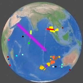 The following are the locations of the various searches and other events:
There are quite a few similarities:
- 9-11: Middle-eastern passengers boarded the planes.
370: Two middle-eastern passengers boarded MH370 with stolen passports. - 9-11: The aircraft disappeared from RADAR because the hijackers turned off the transponders.
370: The transponders quit working. - Both: Voice communication was lost between ATC and the planes.
- Both: Air Traffic Control could not follow the lost flight because of the sea of blips caused by private aircraft.
- Both: The military later reconstructed the aircraft tracks using manual position tracking of RADAR recordings.
- 9-11: Authorities didn't know anything unusual was wrong until the second plane hit the towers.
370: Authorities didn't realize anything unusual was wrong until Vietnam called Malaysia reporting a missing flight. - 9-11: By the time military jets were scrambled and arrived on the scene, all of the hijacked planes
had already crashed.
370: By the time planes were launched, the flight had left the area covered by RADAR.
There are several:
- Pilot suicide
- A fire killed everyone on board but the autopilot kept flying the plane.
- Cracks decompressed the aircraft
- Terrorists crashed it into the sea
- Pirates tried to steal the airplane
- A passenger spread Ebola or another deadly disease to everyone. They sunk the plane deep to prevent contagion.
- A pilot accidentally decompressed MH370, killing all but himself. He then flew to a deep area to die honorably.
- The pilot believed from a fake website that a hidden island existed in the area where he took the plane.
There are several items about the pilot, Capt. Zaharie Ahmad Shah:
- His wife left him the day before the disappearance.
- Shah enjoyed watching the renowned atheist Richard Dawkins.
- He got a 2-minute call minutes before the flight from an unidentified woman calling on a cell phone obtained with a false identity.
- He supported the Malaysian opposition leader, Anwar Ibrahim, who was sentenced to jail for sodomy the day before the disappearance.
- He was very upset because the liberal party was being suppressed by the government.
- His appointment calendar had no social or professional items on it scheduled after March 8.
- He had a flight simulator set up in his home.
- A deleted file was found in the flight simulator computer for a flight plan to a landing on a small island in the southern Indian Ocean with a small runway.
- The FBI recovered data from Capt. Shah's flight simulator for the path of MH370
This information has not been released until recently. A flight plan path was released earlier.
There are no islands with suitable landing strips in the area where MH370 was heading.
There are no islands at all in the direction the flight simulator was set to take the plane.
Here is a list of possible islands and settings:
| Possible Indian Ocean Islands for MH370 Landing | |||||||
|---|---|---|---|---|---|---|---|
| LOCATION | MH370 RANGE (mi) | ISLAND SIZE (mi) |
AIRSTRIP LENGTH (mi) |
HEADING FROM ANDAMAN SEA (°) | HEADING DEVIATION (°) |
ISLAND INHABITANTS | ISLAND CONDITIONS |
| Kuda Huvadu Maldives | 2530 | 1.5 | 0.69 | 261.0 | 95.0 | Pop 2500 | Fishing Village |
| Diego Garcia | 2820 | 13.7 | 2.2 | 239.5 | 73.5 | Pop 4200 | Military base |
| Rodrigues Island | 3800 | 11.6 | 0.83 | 229.5 | 63.5 | Pop 41600 | Small plane airport |
| Ile Amsterdam | 4220 | 6 | helipad | 198.5 | 32.5 | Research station | Dormant volcano |
| Ile Saint-paul | 4270 | 3 | none | 198.0 | 32.0 | Research cabin | Volcanic crater |
| Kerguelen Islands | 5150 | 88 | none | 198.0 | 32.0 | Research station | Glaciated |
| Heard Island | 5270 | 18 | none | 194.0 | 28.0 | Uninhabited | Glaciated |
| New Island Commonwealth | 3840 | (165) | (2) | 173.3 | 7.3 | Imaginary island | Scam website |
| Cocos West Island | 2280 | 5 | 1.6 | 173.0 | 7.0 | Pop 500 | Resort |
| West search area | 3600 | - | - | 172.0 | 6.0 | From Inmarsat | Ocean |
| McMurdo Ice Runway | 6340 | 3429 | 2.4 | 169.0 | 3.0 | Research Station | Antarctica |
| Diamantina Deep | 3880 | - | - | 168.0 | 2.0 | Deepest spot | Indian Ocean |
| Simulator setting found | 4910 | - | - | 166.0 | 0.0 | Deep ocean | No land |
| East search area | 3300 | - | - | 157.5 | -8.5 | From Inmarsat | Ocean |
| Rottnest Island | 3970 | 6.6 | 0.89 | 153.8 | -12.2 | Research station | Preserve and tourism |
| Australia North Island | 3700 | 1.3 | 0.3 | 153.0 | -13.0 | Seasonal fishery | Gravel airstrip |
| Australia East Wallabi Island | 3700 | 1.8 | 0.42 | 153.0 | -13.0 | Research station | Gravel airstrip |
| Christmas Island | 2370 | 13 | 1.3 | 146.7 | -19.3 | Pop 1800 | Rainforest |
| Chicago O'Hare | - | - | 2.4 | - | - | - | For airstrip comparison |
| Kuala Lumpur | - | - | 2.5 | - | - | - | For airstrip comparison |
| MH370 Capabilities | 3200 | - | 1.0 | - | - | - | For comparison |
The range figures include the 1000 miles MH370 flew from Kuala Lumpur to the south end of the Andaman Sea.
New Island Commonwealth is a fictitious island located approximately where the
flight simulator showed the practice flight ended.
The website looks real, with maps, an aerial view, and a history. It even has offers for real
estate for sale on the island. The capital city name is Putney.
It is possible that Capt. Zaharie Ahmad Shah was fooled by this website and believed that the
island was real, but hidden from the public.
Green cells in the table are within the limits of the Boeing 777 that was MH370.
The flight simulator has been revealed to have flight simulations programmed for Malé International in the Maldives, Diego Garcia base, three airports in India, and McMurdo Station Ice Runway in Antarctica.
Friends said he was using those locations to calibrate his simulator.
Notice how close the east and west search areas are to the locations of Diamantina Deep and the map plot of New Island Commonwealth.
People have been fooled by many other events over time:
- In 1910, many people believed they had to take "comet pills" because the earth passed through the tail of Halley's Comet.
- Millions believed the earth was being invaded on 10/30/1938 while listening to the CBS broadcast of a radio play ("The War of the Worlds").
- The Nigeria email scams
- Democrats and the liberal news media have many people believing that Republicans cheated to win the 2000, 2004, and 2016 elections and that Democrats did not cheat in 2020.
- People have been tricked into believing that the 09/11/2001 attacks were staged by the government.
- People believed the phishing calls saying they had won a Publisher's Clearinghouse
Sweepstakes and gave sensitive ID information to identity thieves.
- The information was used to change their voter registrations so they could not vote.
- NOTE: PCH never calls the winners. - Too many people believe that criminals will obey gun control laws.
The one clue that the website is a fake is that it has many paintings and very few photographs.
There are quite a few, but most are disproved:
- The plane was shot down during a military drill that went horribly wrong. †
- Rapper Pitbull predicted MH370 would disappear in his lyrics. ‡
- The US government used remote control to take control of the plane and hide it. † ‡
- MH370 landed on Diego Garcia, near the Maldives. †
- Russian news: MH370 was hijacked, flown to Kandahar Afghanistan, and the occupants were taken captive. † ♠
- Al Qaida hijacked MH370 and took it to an unknown location to keep for use as a future weapon. †
- MH370 hid behind another plane. † ♣
- An elaborate life insurance scam was attempted. ♦
- The pilot believed from a fake website that a hidden island existed in the area where he took the plane.
- Aliens abducted MH370. † ‡ ♥ ♠
- The Illuminati - MH370 was the 404th 777 to be produced, and HTTP error 404 means "not found". ♥
- Edward Snowden hacked the plane. ♥
- The crew was taken over by satan. ♥
- Electronic warfare devices were used to cloak the plane. ♥
- Asian Bermuda Triangle † ♥
-
KEY:
† Inmarsat pings disprove this.
‡ A very vague prediction
♣ It didn't have to. It looked like one of the many private planes on the RADAR.
♦ Nobody on the plane had large amounts of life insurance.
♥ Huh??? Probably a wild theory
♠ Discovery of the flaperon disproves this.
The following are the most likely possibilities, in order of decreasing probability:
- MH370 is accidentally found many years later by people working on something else.
- Searchers find MH370 where ocean currents have taken it.
- Searchers find that MH370 has broken up and is scattered over a large area.
- Searchers find MH370 in one of the search patterns.
- MH370 is never found because it sunk into deep bottom mud.
- MH370 is never found because nobody happens to look where it is.
- Any one of the conspiracy or supernatural theories listed above is true.
- Anything else that nobody has thought of yet
The following is the page author's educated guess of the most likely theory of what happened:
- Something unknown happened on MH370 to cause it to fly south on autopilot.
- MH370 soft-landed on the sea without crashing.
- MH370 then slowly sunk into the sea,
- The pressure of the ocean partially crushed MH370, making the infrasonic sound.
- MH370 maintained neutral buoyancy as ocean currents carried it hundreds of miles from the landing site.
- The searchers found nothing because the plane was no longer there.
- Months later, MH370 crashed into some undersea peak and disintegrated.
- Parts of MH370 washed up on beaches at the western end of the Indian Ocean.
- Some pieces may reach the Atlantic Ocean.